
What's New
-Fixed a bug in the map downloading process.
-Changed user location icon in the map.
-Improved efficiency of GPS in map.
App Description
Tahoe Rim Trail Hiker is a smartphone guide for your hike or mountain bike ride on the Tahoe Rim Trail. Tahoe Rim Trail Hiker use a combination of your phone's GPS, downloaded topo maps, and the Apple Maps interface to accurately locate your position on the trail. No phone service? Not a problem -- your phone's GPS pinpoints your location on top of topo maps downloaded as part of the app.
The trail is color coded according to allowed use for hikers, horses and bikers. An elevation profile of the Tahoe Rim Trail is displayed in the Profile tab of the app. It shows you the elevation of the trail plotted against distance along with your current location on the trail.
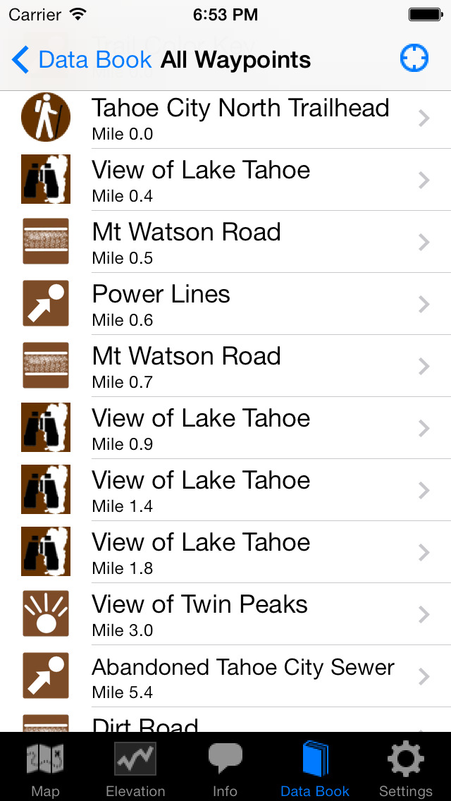
Over 500 waypoints along the 173-mile Tahoe Rim Trail are displayed both on the map and in the "Guide" tab of the app. (The free demo has 56 waypoints along 20.3 miles.) A Trail Register allows you to post comments about any waypoint and view other hikers' comments. This feature can be helpful, for instance, to obtain information about upcoming water sources.
The types of waypoints in the full version of the app include:
-->Trailheads and parking information
-->Water sources (including the reliability of each water source)
-->Tenting sites/camping sites
-->Lake Tahoe views and other views
-->Trail junctions
-->Picnic areas, campgrounds
-->Paved and dirt roads
-->Other Landmarks
-->Privies/restrooms
-->Restaurants, stores, lodging
There are also markers on the map every mile of the trail track.
Clicking on a waypoint on either the Map or in the Guide opens a detail page for the waypoint, providing further details about that particular waypoint. Details include the waypoint's mileage point and elevation, photographs of the waypoint, distance to the next reliable water source, a Trail Register where you may post comments and read other users' comments, and other details that will help you during your hike, and help you plan your hike.
About the Tahoe Rim Trail: The Tahoe Rim Trail is a 173-mile trail that circles beautiful Lake Tahoe in the Sierra Nevada mountain range. The trail passes through California (113.5 miles) and Nevada (59.5 miles). 50 miles of the trail overlap the Pacific Crest Trail and 31 miles overlap the Tahoe-Yosemite Trail. The trail is broken into 8 sections, ranging from 17 miles to 32 miles each. Many hikers complete the entire Tahoe Rim Trail all at once while others complete the trail section by section. Countless others enjoy day-hiking and mountain biking the trail.
iPhone Screenshots
(click to enlarge)


iPad Screenshots
(click to enlarge)


App Changes
- June 18, 2014 Initial release
- August 08, 2014 New version 2.0.3
- September 19, 2014 New version 2.1
- October 05, 2014 New version 2.1.1
- October 12, 2014 New version 2.2
- October 20, 2014 New version 2.2.3
- February 06, 2015 New version 4.0
- February 26, 2015 New version 4.1
- April 27, 2015 New version 4.2
- May 04, 2015 New version 4.3
- May 08, 2015 New version 4.4
Other Apps From Guthook Hikes, LLC