
App Description
This application is intended to confirm and verify the flight route of aircraft in Japan. Complete the air route by forming a connection in four steps from the departure to the arrival of the aircraft. The flight route is based on the Aeronautical Information Publication (AIP) published by the Ministry of Land, Infrastructure, Transport and Tourism.
■ Route creation
Create a route from the departure airport to the arrival airport using the stored flight routes (DEPARTURE, ENROUTE, ARRIVAL, APPROACH).
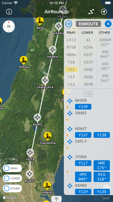
■ Full display of ENROUTE
Shows all routes for RNAV, LOWER ATS ROUTES, OTHER ROUTES, OCEANIC TRANSITION ROUTES.
■ Detailed route display
Displays individual routes for DEPARTURE, ENROUTE, ARRIVAL, and APPROACH.
■ Waypoint display
Displays a list of waypoints that make up ENROUTE and location information.
■ Flight log
When you actually fly, you can record the flight route using the location information. It is possible to confirm and verify the flight route from the recorded information at a later date. Please follow the airline's instructions when using location information on board. Also, since the use of location information consumes a lot of battery power, please turn on / off the location information at sufficient intervals (example: 5 minutes or more) when recording.
■ Target airports
Routes can be created between the following airports.
Wakkanai, Rishiri, Monbetsu, Memanbetsu, Nakashibetsu, Kushiro, Asahikawa, Obihiro, Sapporo/New Chitose, Sapporo/Okadama, Okushiri, Hakodate, Aomori, Odate-Noshiro, Akita, Hanamaki, Shonai, Yamagata, Sendai, Fukushima, Hyakuri, Narita INTL, Chofu, Tokyo INTL, Oshima, Niijima, Kozushima, Miyakejima, Hachijojima, Niigata, Noto, Toyama, Kanazawa/Komatsu, Matsumoto, Shizuoka, Nagoya, Chubu Centrair INTL, Tajima, Osaka INTL, Kobe, Kansai INTL, Nanki Shirahama, Oki, Tottori, Miho, Izumo, Okayama, Hiroshima, Iwami, Yamaguchi-Ube, Takamatsu, Tokushima, Matsuyama, Kochi, Tsushima, Iki, Kitakyushu, Fukuoka, Oita, Saga, Nagasaki, Fukue, Kumamoto, Amakusa, Miyazaki, Kagoshima, Tanegashima, Yakushima, Amami, Kikai, Tokunoshima, Okierabu, Yoron, Naha, Kume Jima, Kitadaito, Minami Daito, Miyako, Shimojishima, Tarama, New Ishigaki, Yonaguni Jima
■ Disclaimer
Each route information is displayed in a straight line based on the coordinate information, and is different from the route that the aircraft actually flies. In addition, whether or not each route can be connected is determined by the presence or absence of waypoints, and the direction of flight is not restricted.The project is not liable for any direct, indirect, incidental or punitive damages incurred by the user as a result of using this application.
iPhone Screenshots
(click to enlarge)


iPad Screenshots
(click to enlarge)


App Changes
- March 30, 2022 Initial release
Other Apps From MAKOTO SASAKI