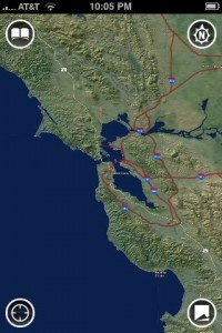
Accuterra maps include some interesting features you won't find in Google Maps. For one, you can use them offline. That is huge if you are and enjoy going on hikes. Anyone who has ever gone to a National Park knows that the cell phone coverage is bad and you're lucky if you can get data service at all. All levels of zoom of the topographic maps are available instantly.
There's something very satisfying about zooming in and out, and scrolling around all without waiting for the images to load. It is completely instant. Fantastic.
Other great features include recording your tracks, creating walking tours (combinations of your tracks and photos), mark waypoints and points of interest, save and share your trails, and view a profile of a hike to gauge the elevation changes.
Here's a quick introduction to the app from the developers.
[youtube hv_yWW9SnhE]
OS 3.0 In-App Purchasing
Versions of the maps updated for OS 3.0 will also include some great in-app purchasing functionality. You'll be able to buy small map regions for areas you are visiting for as little as $0.99. Think of a trip to Lake Tahoe and the ability to add the detailed map for that area with just a couple touches. Should be very powerful. The versions that take advantage of OS 3.0 should be hitting the app store soon.
Currently there are two free versions available in the app store. These include the Bay Area and Yosemite example applications.
More screen shots after the jump.


 :: INFORMATION PACKED