
What's New
Fixed intermittent failures within the search functionality.
If you like the app please leave an app review.
App Description
From the producers of GB Maps (featured in Ordnance Survey's OS OpenData innovative application showcase)
Beautifully detailed maps supplied by Ordnance Survey
Northumberland (National Park) Maps provides an offline (no mobile signal required) mapping reference and navigation aid whilst travelling throughout the Northumberland (National Park) region by footpath, road, rail, canal, lake and river. Intuitive route and waypoint management features are implemented enabling creation, modification, deletion, import and export of routes. An offline search facility can locate places, roads, post codes and hills within the region. Worldwide online Apple Maps (Standard, Satellite and Hybrid) with map features that users are used to are available on both offline and online maps as well as providing 3D buildings on Apple maps (where available)
Maps
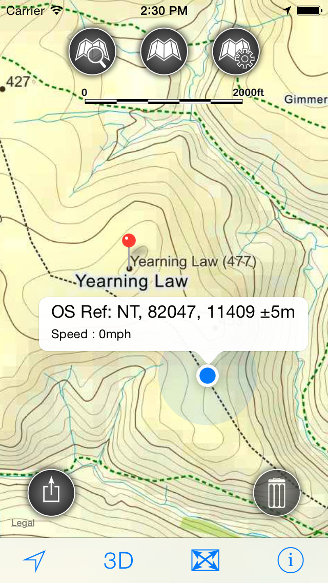
7 levels of offline 2014/2015 Ordnance Survey map detail from national overview to street view within the region. (No data connection required)
More detailed maps load as the view is zoomed. The OS recommended viewing scales for the detailed maps are approximately:
1:1000,000 (The whole of GB is covered at this map scale)
1:250,000
1:50,000
1:25,000
1:10,000 ( (Roads/streets are labelled by name))
The map region of the detailed maps covers a rectangular region around the national park boundary, The following towns, which are outside of the national park boundary are included : Jedburgh, Coldstream and Kelso
- Contours with height information and annotated height points
- Extensive footpaths from ©OpenStreetMap contributors
- National Park boundary demarkation
App
- Route/Waypoint management
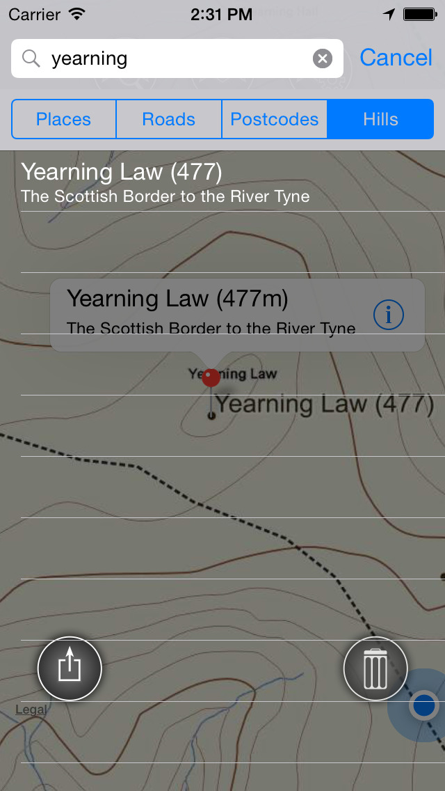
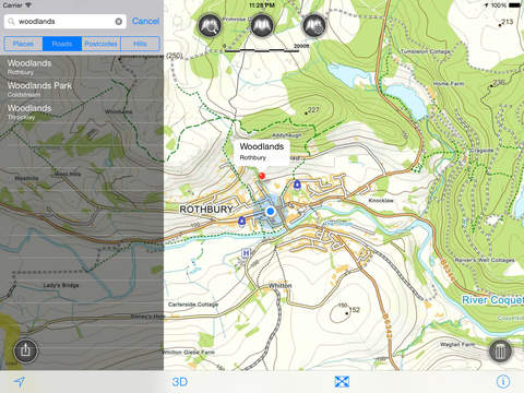
- Offline search functionality with searchable locations (places, roads, post codes and hills). (For the place search a location's latitude and longitude is accurate to 0.1 of a minute of the centre point of the 1x1 km National Grid square in which the name falls)
- Detailed hill information, including height, OS Grid Ref, latitude and longitude, region, parent, classification, drop and hill specific links to Streetmap, Geograph and Hill Bagging web sites
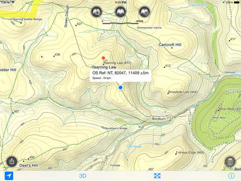
- Display of current GPS position as OS Grid Reference or WGS84 latitude and longitude
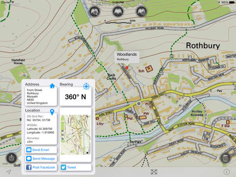
- "Share My Location" allowing users to share an image of their current location and location references. Buttons are provided to share location information by Facebook, Twitter, iMessage/SMS and e-mail
- Online access to worldwide Apple Standard, Satellite and Hybrid maps
- Apple 3D Buildings are displayed on Apple Standard maps
- Apple maps contain Points of Interest
- User location can be tracked with or without heading on all online and offline maps (GPS capable devices only)
- Display of scale bar in either metric or imperial units
- Display of current speed
- Zoom, pan, rotation of all maps
- Pitch of Apple Standard and Ordnance Survey maps
- Selection of current location annotation for display of speed and location data
- User setting for speed display in Miles per Hour (mph) or Kilometres per Hour (kph)
- Selection of search result pin annotations to display location information
- Collective deletion of search result annotation pins
- A user guide is provided within
The OS search data was published by Ordnance Survey in 2014.
Extracts from "The Database of British and Irish Hills" v14 published 22/04/2014 (ref. http://www.hills-database.co.uk/index.html )
No warranty
The data is supplied by Apple, Ordnance Survey, contributors to OpenStreetMap and Database of British and Irish Hills
The Information is licensed 'as is' and the Information Provider and/or Licensor excludes all representations, warranties, obligations and liabilities in relation to the Information to the maximum extent permitted by law
The Information Provider and/or Licensor are not liable for any errors or omissions in the Information and shall not be liable for any loss, injury or damage of any kind caused by its use
This app is not a substitute for a paper map and compass.
iPhone Screenshots
(click to enlarge)


iPad Screenshots
(click to enlarge)


App Changes
- May 06, 2015 Initial release
- May 14, 2015 Price decrease: $1.99 -> FREE!
- May 16, 2015 Price increase: FREE! -> $1.99
- September 29, 2015 Price decrease: $1.99 -> $0.99
- November 07, 2016 New version 2.0.2
- November 07, 2016 Price increase: $0.99 -> $1.99
- June 15, 2019 New version 2.1.1
Other Apps From JOMO Solutions Ltd.