
What's New
This is a mandatory release if you are using the ArcGIS™ basemaps as previous version being discontinued by Esri™.
• search feature when using an online basemap (Apple, ArcGIS™, Mapbox™)
• upgraded to use newest versions of ArcGIS™ and Mapbox™ with new basemap choices including OpenStreetMap™
• improved media use for creating placemarks and routes
• improved social share options
• new weather layer (requires a free account with openweathermap.org)
• fixed GPX files not displaying on devices using iOS 13
• other bug fixes
App Description
Exploring geocaches with friends and family is a great outdoor activity suitable for every age. Make it even more fun using GeoView Cache!
FEATURES
• Simple to use and works on large and small displays
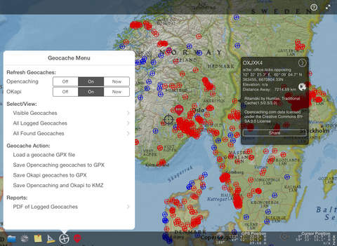
• Retrieve geocaches from Opencaching Network websites
• Import GPX files containing geocaches from other web sources (e.g. geocaching.com and terracaching.com)
• Log geocaches, tag them as found, as well as other tags, add notes and photos
• Submit logs directly to Opencaching Network websites
• Export your field notes to submit logs to geocaching.com
• Import your already logged/found geocaches from Opencaching Network websites
• Import already logged/found geocaches using a GPX file from geocaching.com
• Create a PDF report of all your logged geocaches containing all logged and tagged information including photos
• Choose from a variety of Apple, ArcGIS™ or Mapbox™ basemaps
• Ability to download static and tiled basemaps from a variety of sources for offline use
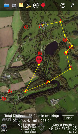
• Straight line compass navigation to geocaches with sound alerts
• Track, elevation profile, save and share your route
• Save and share geocache locations using GPX or KMZ files
• Find detailed information about a particular geocache from the source website
• Filter and display your results sorted by distance from a source (GPS location, cursor position on the map, or what3words position)
• Search for a geocache that may or may not be on your current map display
• Filter your results by difficulty, terrain, rating and size
• Ground elevation is automatically added to the cache, GPS and cursor locations
• what3words may be used to easily find and share locations
• Share your geocaches, track points and what3words locations using social media
• Geocache, GPS, and cursor locations can be displayed in lat/long, utm or what3words
• Measure distance and calculate travel time with customizable travel modes
• Share your files with your PC, Mac and with your friends using Dropbox
Requirements: Compatible with iPhone, iPad & iPad mini running IOS 11.0 or later. Requires an Internet connection for Apple, ArcGIS™ or Mapbox™ basemaps (offline versions can be downloaded) and geocache services. For GPS location information on iPads, device models with 3G are required. An iCloud account is required for logging geocaches.
Note: Continued use of GPS running in the background can dramatically decrease battery life.
Visit http://www.geoviewcache.com for more information and updates.
iPhone Screenshots
(click to enlarge)


iPad Screenshots
(click to enlarge)


App Changes
- January 31, 2015 Initial release
- February 12, 2015 New version 1.1.0
- February 21, 2015 New version 1.2.0
- March 13, 2015 New version 2.0.0
- March 17, 2015 Price increase: $0.99 -> $1.99
- March 24, 2015 New version 2.1.0
- May 06, 2015 New version 2.2.0
- June 08, 2015 New version 2.2.1
- July 02, 2015 New version 2.3.0
- July 09, 2015 New version 2.4.0
- July 11, 2015 Price increase: $1.99 -> $4.99
- July 27, 2015 New version 2.4.1
- September 02, 2015 New version 3.0.0
- October 05, 2015 New version 3.0.1
- November 26, 2015 New version 3.0.2
- December 17, 2016 New version 3.1.0
- June 15, 2019 New version 3.1.6
- September 11, 2019 Price decrease: $4.99 -> $3.99
- November 05, 2019 New version 3.2.0
- July 15, 2020 Price decrease: $3.99 -> $2.99
Other Apps From EZStuff Software Inc