
What's New
• iOS 16 crashing fixed.
• Nice UX and speed improvement.
App Description
Download all available USGS topographic maps and import Geospatial PDF maps for off-line use at full undistorted resolution.
Topo Reader is designed for road trips, camping, hiking, exploration and geographical history. Map images are accurately center aligned regardless of datum and placed on top of Apple's map kit for easy referencing and intuitive touch navigation.
This software utilizes the latest capabilities of IOS with a fast start up, map rotating, unbeatable full detail resolution. Map downloads dispatch in the background so you can continue using the app.
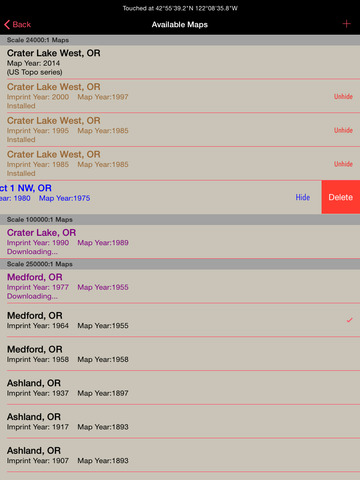
Topo Reader can install for use 422,664 U.S. Geological Survey current and historical topographical maps describing the topography of every region and island territories of the United States of America. Historical versions date as far back as year 1879. Install a map quad by pressing and holding a point on the reference map and discover the maps available at that location and the unique names given to every quad by the cartographers.
Import geospatial PDF maps from the web, AirDrop, Finder, iTunes and email. Even at trailheads there are QRCode for maps that copy and install onto this app! Local and national park services offer PDF maps from their web sites. Even aeronautical sectional maps with embedded geospatial metadata that you can download in installed into Topo Reader.
Easy see all your installed maps by zooming out and they all become a colorful violet and partially transparent so you can spot your map. Installed maps are managed in a table format which can be sorted by name, distance, and scale. Multiple versions of the same map can be stacked on top of one another and made visible or hidden using two finger swipes.
Planning a hike somewhere and want to know the distance of your jaunt. Download the map and use the dual mode ruler to measure the path distance. Select the create Route option and draw and record your planned route.
Purchase a subscription for unlimited map downloading. A subscription stops ads and doesn't auto-renew. The first few map download are complementary.‡
Features:
• No need for cellular service to use
• Use the GPS on downloaded topo maps while offline*
• Dual mode ruler with orthographic line and path measuring
• Waypoints with Augmented Reality finder
• Routes path creation
• Tracks/bread-crumb GPS location recording*
• Full app usability while maps download in the background
• Displays footprint grid and quad names
• Aligns map datums to WGS84 (GPS) coordinates
• Dynamic map stitching
• Cropping of map margins for one big map grid
• Automatic USGS topographic map download for your current location
• Uses GPS location service to identify your location on a topo map*
• Miles, Feet, Kilometers, Meters, Nautical Miles units
• MGRS, UTM, and geodetic latitude and longitude coordinates
• Import geospatial PDF maps downloaded from the USGS and other sources in zip or regular file formats
• Enter coordinates in decimal, minutes and second formats
• Map rotation and orients map to follow your heading
• Imports GPX file formats waypoints
• Email, AirDrop and SMS text waypoints, tracks and routes as GPX files (one subscription purchase required to permanently enable).
Not currently supported: Geo TIFF; OCG layer selection used in current USTopo USGS maps.
Not all geospatial metadata formats and datums are supported for imported PDF maps.
Limited KML features supported.
* Not preloaded with maps. WiFi recommended. Downloading queue does cap at around 36 maps.
** Continued use of GPS running in the background can dramatically decrease battery life. Location feature may not function on iPod and wifi-only iPad devices without GPS hardware.
‡ After a subscription period expires, advertisement may resume from usage of the import features.
iPhone Screenshots
(click to enlarge)


iPad Screenshots
(click to enlarge)


App Changes
- November 17, 2014 Initial release
- April 15, 2015 New version 2.1
- March 05, 2016 New version 4.0
- July 05, 2016 New version 4.3
- December 17, 2016 New version 5.0
- December 21, 2016 New version 5.1
- June 14, 2019 New version 7.2
- September 16, 2023 New version 8.1
Other Apps From Delcartes LLC