
What's New
GPX improvements with route tracks and waypoints.
Supports CDATA XML data in imported GPX files.
App Description
NP Maps Zion app displays high resolution official National Park Service maps of Utah and Nevada on you iPhone and iPad for GPS** and offline use!
NP Maps Zion app displays official National Park Service maps in full resolution of Zion National Park and more for you see your GPS** location on them realtime. Plus, NP Maps Zion downloads official US Geological Survey topography maps for all of Utah and the USA.*
This app is priceless for road trips, hikes, camping, exploring, planning and more.
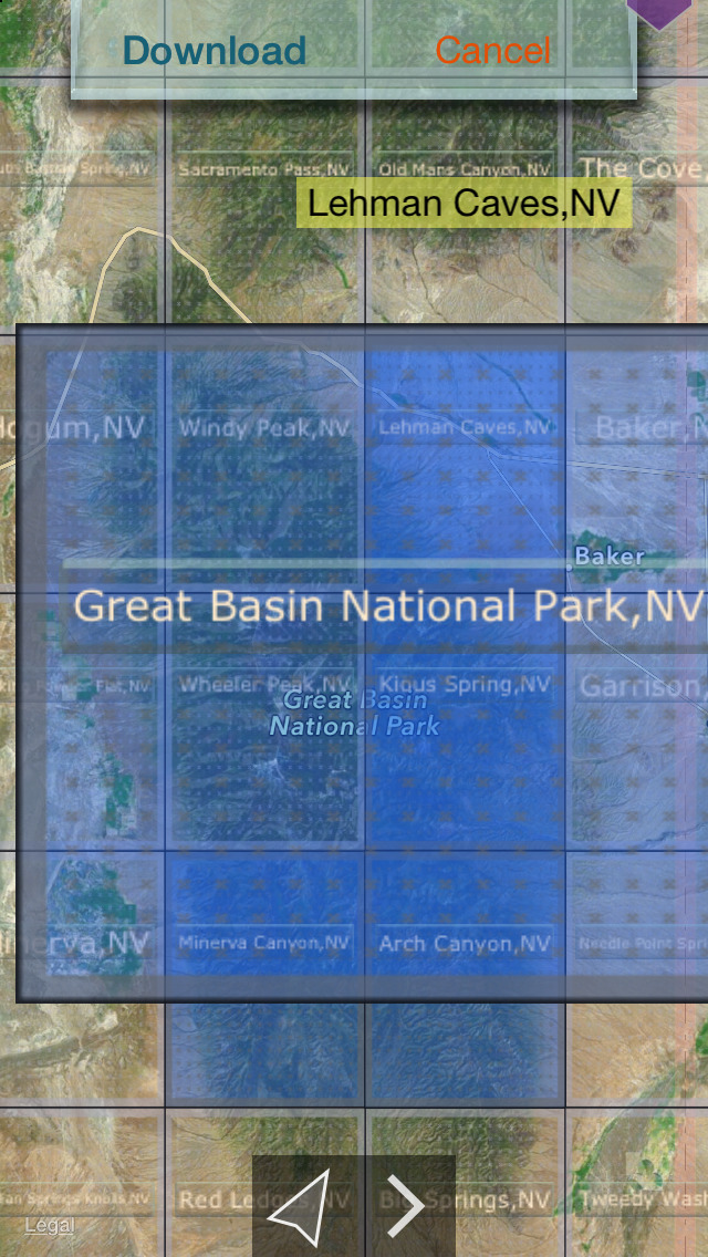
Logical and intuitive to use. Park and topography maps are geospatially integrated with Apple Maps for a familiar interface and for navigating a visual catalog of maps. A marvelous index into an extensive library covering Utah and Nevada allows you to select maps for install all with a simple touch along your planned route of travel.
With a subscription purchase you have complete map coverage in Nevada and Utah from where you start your travels to the national parks. Because many of these wilderness regions have no data service, select and download maps now, or when online, so you can enjoy using this app as it was intended: no internet connection. And, this app can detect internet service and automatically install USGS topography or NPS map for your current location if not already done.
Features:
• Preloaded with map for Zion NP: one(1) NPS and two(2) USGS topography 100k scale maps
• Access a library of over 120 NPS maps and 67,000+ USGS Topography maps
• Full rendering high resolution maps
• Find geographic features worldwide with a powerful geo-code search
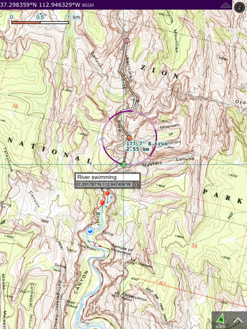
• Waypoints
• Route path creation
• Track/bread-crumb GPS path recording**
• Shows your current GPS location**
• Dual mode ruler with orthographic line and path measuring
• Full app usability while maps download in the background
• Footprint grid index with quadrangle names for visual map selection
• Aligns differing map datums to the WGS84/GPS coordinates
• Automatic map download for your current location
• Miles, Feet, Kilometers, Meters, Nautical Miles units
• Latitude and Longitude coordinate display in decimal or arc minutes and seconds
• Import geospatial PDF map files via web, email attachment & iTunes
• Import and export waypoints using GPX format
• Detailed integrated help
• Supports rotation and follows heading map orientations
• No need for cellular service to use installed maps
• No advertisements
• Subscription not required to use app. Purchase of a subscription allows for downloading any number of USGS and NSP map in the app index data base. Maps remain fully functional after subscription ends. A active subscription is shared with the other NP Map apps variations and the Topo Reader app.
Below are the of National Park Service and topography maps available for downloading,
National Parks:
Zion National Park (built in /w topography maps)
Capitol Reef National Park
Great Basin National Park
National Monument:
Grand Canyon - Parashant National Monument
National Preserves and Reserves:
Mojave National Preserve
City of Rocks National Reserve
National Recreation Area:
Lake Mead National Recreation Area
Historical USGS topography maps scales:
24K : 1 7.5x7.5 arc minute quadrangle
48K : 1
62.5K : 1
100K : 1
125K : 1
250K : 1
* Not preloaded with all maps. Select and install all you need. WiFi recommended.
** Continued use of GPS running in the background can dramatically decrease battery life. Some iPad & iPod models do not have GPS and compass hardware.
iPhone Screenshots
(click to enlarge)


iPad Screenshots
(click to enlarge)


App Changes
- July 31, 2015 Initial release
- August 04, 2015 Price decrease: $3.99 -> $1.99
- August 12, 2015 Price decrease: $1.99 -> $0.99
- August 15, 2015 Price increase: $0.99 -> $1.99
- August 21, 2015 Price decrease: $1.99 -> $0.99
- August 24, 2015 New version 3.2
- August 26, 2015 Price increase: $0.99 -> $1.99
- September 01, 2015 Price decrease: $1.99 -> $0.99
- September 05, 2015 Price decrease: $0.99 -> FREE!
- September 14, 2015 Price increase: FREE! -> $1.99
- February 28, 2016 Price decrease: $1.99 -> $0.99
- March 06, 2016 New version 4.0
- March 06, 2016 Price decrease: $0.99 -> FREE!
- July 11, 2016 New version 4.3
Other Apps From Delcartes LLC