
What's New
- We’ve made overall performance improvements and squished few bugs!
App Description
The iNATS application is designed to assist Pilots in operating the North Atlantic Track System (NATS).
The Application is centered around the FIR entry point for the Oceanic area, once the user has entered this the App will identify the correct FIR and all the associated procedures required. The user will be guided through each step of the Atlantic crossing procedure from obtaining the oceanic clearance to the HF selcal check.
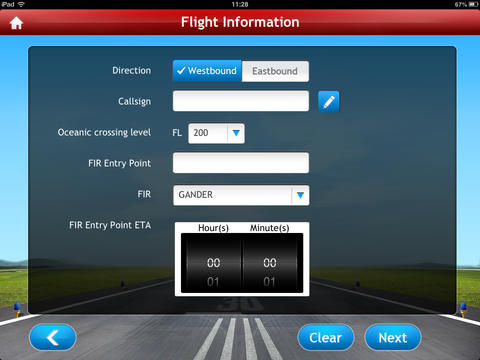
The App has either AUTO mode or direct access mode. The AUTO mode will lead the user to a flight information page where the user is asked specific flight information , once entered the App will guide the user through the entire Oceanic crossing procedures. The direct access is available for quick information access.
Additional features Include.
•Notes that can be edited by the user for company specific procedures
•General OTS Information
•Contingency procedures: Contingency procedures including weather deviations – just enter direction and required deviation and the App will generate the procedure to follow.
•Daily enroute weather charts and NAT Track messages
•Alternates Information: Some of the airports around the North Atlantic are displayed with pins on a nice zoomable map to enhance situational awareness , once selected a simple airport diagram will be displayed with runway dimensions , local time and if applicable ATIS information.
•Great circle track and distance calculator
•Standard Nav Plotting symbols
•Volmets
•Abbreviations
•ATS satcom numbers
•Feedback form for user’s feedback
Disclaimer:
The content provided in this application is designed to provide helpful information however is not a replacement for your official company documentation.
iNATS does its best to present information that is current, clear and accurate. However, this information should not be construed to be complete or exhaustive.
iNATS disclaims all liability and responsibility for any direct or indirect loss or damage which may be suffered by any recipient through relying on anything contained in or omitted from this document.
You agree to access and use the Application in accordance with all applicable laws and regulations. You agree not to use the Application for any illegal or wrongful purposes.
If you identify any such content that is harmful, malicious, sensitive or unnecessary, we request that you contact us via email so we may rectify the problem.
There is a feedback form within the App that will automatically send feedback to the developer when a WIFI connection is available. This can be used for any feedback including a request for additional features . for example the user may request inclusion of an additional alternate airport.
iNATS will be kept updated and the user will be notified when an update is required.
The North Atlantic Tracks System (NATS) is the principal system of routes between Europe and North America. North Atlantic Tracks (NAT) are trans-Atlantic routes that stretch from the northeast of North America to western Europe across the Atlantic Ocean. They ensure aircraft are separated over the ocean, where there is little radar coverage. These heavily-traveled routes are used by aircraft traveling between North America and Europe, flying between the altitudes of 28,500 and 42,000 feet, inclusive. Entrance and movement along these tracks is controlled by special Oceanic Center air traffic controllers to maintain separation between airplanes. The primary purpose of these routes is to provide a Minimum Time Route (MTR).
(Source: Wikipedia)
iPad Screenshots
(click to enlarge)


App Changes
- April 22, 2012 Initial release
- May 30, 2012 New version 1.1
- June 19, 2012 New version 1.2
- November 01, 2012 Price decrease: $14.99 -> $5.99
- December 11, 2012 New version 1.3
- January 08, 2013 New version 1.4
- February 27, 2013 New version 1.5
- April 26, 2013 New version 1.6
- November 05, 2013 New version 1.7
- July 26, 2014 New version 1.8
- February 15, 2016 New version 1.9
- March 07, 2016 New version 2.0
Other Apps From Extentia Information Technology