
What's New
Late Summer 2023
Updates: Devils Tower, Caribou-Targhee
Updates: Contains the latest data by the National Park Service (NPS), Bureau of Land Management (BLM), United States Forest Service (USFS) and recreation.gov.
App Description
Be prepared! Plan your next trip to one of the great Wyoming parks. Download maps and guides before you venture into the Wi-Fi free wilderness.
Discover
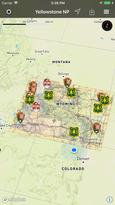
- 70+ national parks, state parks, monuments, forests
- 140+ neatly folded maps by the National Park Service, Bureau of Land Management, United States Forest Services, and other agencies.
- Motor Vehicle Use Maps (MVUM), Motor Vehicle Travel Maps (MVTM) and visitor maps for national forests.
- 1,600+ campgrounds and campsites
- 2,600+ trails and trailheads
- 36.000+ points of interests
Plan
- Download maps, park brochures, and newspapers. These downloads are ready when you are offline and off the grid in the great outdoors.
- Download arbitrary map sections as offline packs.
- Photo galleries, panorama views.
- Share links to parks and maps with friends
Have fun
- GPS and GPX support: record your hikes, import GPX routes, tracks and waypoints for your hiking trails.
- Detailed national park information: alerts, news, visitor centers, campgrounds, driving directions, weather.
- Open your favorite maps app to get a route to the selected park.
- Current weather conditions, easy access to multi-day forecasts, sunrise and sunset times.
- Push notifications for park alerts, park news, weather warnings
So download maps and guides for:
Amsden Creek
Bear River
Beartooth
Bighorn
Bighorn Canyon
Black Hills
Boysen
Bridger-Teton
Bud Love
Buffalo Bill
Camp Creek
Casper Mountain
Chain Lakes
Cody
Continental Divide
Cottonwood Draw
Devils Tower
Fort Laramie
Fossil Butte
Glendo
Grand Teton
Guersey
Hawk Springs
Hot Springs
Jackson
John D Rockefeller Jr
Keyhole
Laramie Peak
Medicine Bow
Ocean Lake
Pinedale
Pole Mountain
Red Rim-Grizzly
Renner
Seminoe
Shoshone
Sierra Madre Mountains
Sinks Canyos
Snowy Range
Soda Lake
Thunder Basin
Wyoming Range
Yellowstone
There are additional useful information and brochures for many Wyoming state parks.
- FULL ACCESS is available for a for $3.49/three month (after a free 3-days trial period) or $2.49/two months or $7.49/year. You can subscribe and pay through your iTunes account. The account will be charged for renewal within 24-hours prior to the end of the current period, and identify the cost of the renewal. Your subscription will automatically renew unless canceled at least 24 hours before the end of the current period. Auto-renew can be turned off anytime by going to your Account Settings in iTunes after purchase.
- Continued use of GPS running in the background can dramatically decrease battery life.
LEGAL
Terms of Use: https://www.icoat.de/pocketmaps/terms
Privacy Policy: https://www.icoat.de/pocketmaps/privacy
iPhone Screenshots
(click to enlarge)


iPad Screenshots
(click to enlarge)


App Changes
- June 16, 2019 Initial release
- July 02, 2019 New version 1.9
- August 18, 2019 New version 2.1
- November 11, 2019 New version 2.4
- January 21, 2020 New version 2.5
- July 14, 2020 New version 3.0
- October 27, 2020 New version 3.3
- August 05, 2021 New version 4.0
- October 15, 2021 New version 4.2
- September 16, 2023 New version 5.9
Other Apps From Alex Gugel