
What's New
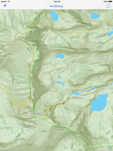
— Now featuring the Mount Whitney Zone from Whitney Portal to Cotton Wood Lakes & Horseshoe Meadows
— This is the offline map of Mount Whitney; see the online version at RobLabs.com/MtW
— We reduced the App Install size by slimming down our offline map data using cool vector techniques and compression.
— Your trip, your privacy — we do not track your location.
— The eπ Offline Map engine is Mapbox SDK for iOS 3.6.3 + WebP + MBTiles.
— This update contains stability and performance improvements.— Now featuring the Mount Whitney Zone from Whitney Portal to Cotton Wood Lakes & Horseshoe Meadows
— We reduced the App Install size by slimming down our offline map data using cool vector techniques and compression.
— Your trip, your privacy — we do not track your location.
— The eπ Offline Map engine is Mapbox SDK for iOS 3.6.3 + WebP + MBTiles.
— This update contains stability and performance improvements.
App Description
This is the `ePi Offline Map` of Mount Whitney and the Mount Whitney Zone. Please see the online map of Mount Whitney at RobLabs.com/MtW
What to see
— Featured locations include Trail Crest, John Muir Trail Junction, Trail Camp, and Outpost Camp
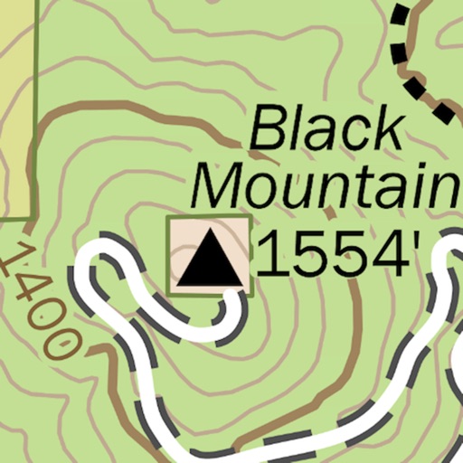
- Topographic trail map of Mt Whitney, Whitney Portal and Lone Pine.
Features
— This eπ Map is completely offline.
— Use your GPS to see your location on the trail.
— Now with beautiful shaded relief.
— Topographic map with 40 feet contour intervals.
— When you have service, get local weather from Weather.gov.
Your trip, your privacy
— Works offline without a network
— After the initial app download from the Apple App Store, no server is necessary
— We don't track your location
— We don't have analytics in our app
— We don't care where you go, we just want you to enjoy yourself safely
eπ Maps is powered by OpenGL with vector based maps built with Open Map Tiles, and hill shaded relief raster maps built with GDAL and WebP.
Usage
— Pan to move
— Pinch to zoom
— Use two fingers to rotate
— Double-tap to zoom in one level
— Two-finger single-tap to zoom out one level
— Double-tap, long-pressing the second, then pan up and down to "quick zoom" (one hand mode)
Legal
— Publisher assumes no liability for safety or condition of roads or trails. Map is not intended for navigational use and is not represented to be correct in every aspect. Consult federal, state, and local laws for current regulations.
— This map is not a legal document. Boundaries may be generalized for this map scale. Private lands within government reservations may not be shown. Obtain permissions before entering private lands.
— © OpenMapTiles for Vector Tile processing
— © OpenStreetMap contributors
— © Open DEM, Open Database License (OdBL), for Contours in metric.
— © USGS, for Hill Shaded Relief and 40 foot contours. Contours derived from the National Elevation Dataset.
— Please see the full terms and conditions at http://RobLabs.com/Legal
iPhone Screenshots
(click to enlarge)


iPad Screenshots
(click to enlarge)

App Changes
- July 14, 2016 Initial release
- July 30, 2016 New version 1.331.2
- June 14, 2019 New version 2.363.582
- June 14, 2019 Price increase: $0.99 -> $4.99
- June 16, 2019 Price increase: $0.99 -> $4.99
- October 21, 2019 Price decrease: $4.99 -> FREE!
- October 28, 2019 Price increase: FREE! -> $4.99
Other Apps From ePi Rational, Inc.