
What's New
- minor bug fixes
App Description
This in-flight aeronautical system contains full airport database of the United States (more than 4.000 airports and 24.000 charts and diagrams) including aeronautical charts and real-time weather information. All flight charts of VFR and IFR airports are regularly updated according to FAA (Federal Aviation Administration) regulations to make our app useful and reliable for every pilot.
DETAILED WEATHER INFORMATION
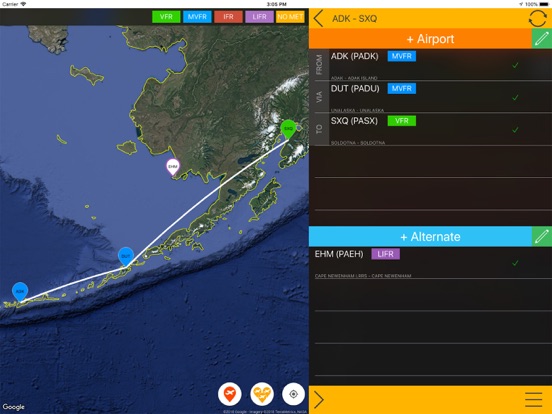
METAR (Meteorological Terminal Air Report) and TAF (Terminal Aerodrome Forecast) data are continuously updated online thus users do not need to refresh data manually. Airport weather information is marked with green (VFR), blue (MVFR), red (IFR) and purple (LIFR) according to the aviation standards. By choosing any of the listed airports you can check the time of latest weather report.
METAR AND TAF DATA ARE DISPLAYED IN A USER-FRIENDLY WAY
Raw weather information is processed into a more understandable transcriptions. METAR data provides information of the following parameters: observation time, flight category, temperature, dewpoint, wind, windgust, visibility, pressure and clouds while TAF data includes detailed weather forecast of the airport.
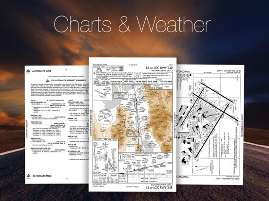
DETAILED CHARTS AND PUBLICATIONS
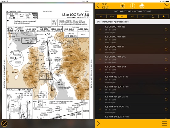
This aeronautical app provides detailed information of all airfields and allows them to be displayed in various categories. This easy access categorizing function helps users to find information more quickly thus makes IFR procedures easier:
• Instrument Approach Procedures - IAP
• Standard Terminal Arrivals - STAR
• Departure Procedures - DP
• Airport Diagrams - APD
• Airport Minimums – MIN
AIRFIELD CHARTS ARE AVAILABLE OFFLINE
After downloading US EFB Aviation Chart you will have access to all data the app provides. The app will update aeronautical charts and documents continuously online but all your charts are going to be stored on your device so you can always use them with no internet conenction.
MAP VIEW FOR BETTER WEATHER INFORMATION
This app allows users to choose airports in a map view. It highlights airports with different colors referring to different weather conditions. This map view helps users to instantly see the most important weather information and choose other airports nearby if necessary.
ADVANCED AERONAUTICAL CHART BROWSING SYSTEM
This comfortable digital flight bag provides users an advanced chart browsing function. The browser let users to search charts according to FAA, ICAO, IATA airport codes.
DISPLAY INFORMATION IN DIFFERENT UNITS
Users can change the default units according to their needs. The following units are available in US EFB Aviation Charts:
• Pressure: hPA – inHG – mmHg
• Temperature: Celsius – Fahrenheit
• Visibility: Km – Sm – Nm
• Elevation: Feet – Meter
• Wind: knot – m/s – km/h – mph
• Altitude (cloud): Feet – Meter
MORE INFORMATION
Please note that, free version allows users to choose 5 airports. With subscription to 'US EFB - Aviation Charts - Charts & Weather for pilots' you can enjoy premium features including: unlimited offline charts (after download), aviation weather (online access) with continuous updates.
If you choose to purchase US EFB - Aviation Charts - Charts & Weather for pilots, payment will be charged to your iTunes account, and your account will be charged for renewal within 24-hours prior to the end of the current period. Auto-renewal may be turned off at any time by going to your settings in the iTunes Store after purchase. Prices are in U.S. dollars, may vary in countries other than the U.S. and are subject to change without notice. No cancellation of the current subscription is allowed during the active subscription period.
Privacy policy: https://www.flygo-aviation.com/privacy-policy-flygo/
Terms of use: https://www.flygo-aviation.com/terms-of-use-flygo/
Enjoy our app & FLY SAFE!
FlyGo-Aviation Team
iPhone Screenshots
(click to enlarge)


iPad Screenshots
(click to enlarge)


App Changes
- June 16, 2019 Initial release
- July 15, 2020 New version 3.3
- October 27, 2020 New version 3.5
- August 06, 2021 New version 3.6
- September 16, 2023 New version 3.7
Other Apps From Flygo-Aviation Ltd