148 Apps on Facebook 148 Apps on Twitter

Tag: Outdoors »

The New Sunset Western Garden Book Review

+ Universal App - Designed for iPhone and iPad
By Jennifer Allen on March 19th, 2013
Our rating: starstarstarstarblankstar :: INFORMATION PACKED
Get those green fingers at the ready with this comprehensive e-book type app offering plenty of information on how to form the perfect garden, no matter how small or large your green space is.
Read The Full Review »

Easy Trails GPS Updates with New Interface and Features

Posted by Kevin Stout on April 5th, 2012
+ Universal App - Designed for iPhone and iPad

Easy Trails GPS, the navigation application made specifically for outdoor enthusiasts, has updated to 6.0 and added new features and interface changes with the release.

The interface for Easy Trails GPS 6.0 has been significantly changed with this update. The interface design was rewritten completely from scratch to keep in mind usability. The new interface displays every feature of the application regardless of the current activity going on, making it easy to switch between Easy Trails GPS’s many features.

Other features added in the release is support for Retina display devices, sharing location via Twitter, the ability to archive up to 1000 tracks and 2500 waypoints, waypoint proximity alerts can be turned on with use of the Notification Center, exporting all track information, and the ability to copy and save waypoint pictures to the clipboard or the iOS camera roll.

Easy Trails GPS is available for $3.99.

CodeRunner Review

iPhone App - Designed for iPhone, compatible with iPad
By Jennifer Allen on March 28th, 2012
Our rating: starstarstarstarblankstar :: UNIQUELY MEMORABLE
A fascinating concept that's unlike all others. It's a great way to make walking exciting.
Read The Full Review »

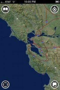
Accuterra Maps by Intermaps

Posted by Jeff Scott on June 19th, 2009

Accuterra maps include some interesting features you won't find in Google Maps. For one, you can use them offline. That is huge if you are and enjoy going on hikes. Anyone who has ever gone to a National Park knows that the cell phone coverage is bad and you're lucky if you can get data service at all. All levels of zoom of the topographic maps are available instantly.

There's something very satisfying about zooming in and out, and scrolling around all without waiting for the images to load. It is completely instant. Fantastic.

Other great features include recording your tracks, creating walking tours (combinations of your tracks and photos), mark waypoints and points of interest, save and share your trails, and view a profile of a hike to gauge the elevation changes.

Here's a quick introduction to the app from the developers.

[youtube hv_yWW9SnhE]

OS 3.0 In-App Purchasing

Versions of the maps updated for OS 3.0 will also include some great in-app purchasing functionality. You'll be able to buy small map regions for areas you are visiting for as little as $0.99. Think of a trip to Lake Tahoe and the ability to add the detailed map for that area with just a couple touches. Should be very powerful. The versions that take advantage of OS 3.0 should be hitting the app store soon.

Currently there are two free versions available in the app store. These include the Bay Area and Yosemite example applications.

More screen shots after the jump.