
What's New
Updated to support iOS 11.
App Description
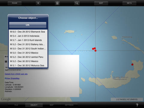
Keyhole markup language (KML) is a standard format used by many mapping and navigation tools to represent geographical information. KML Map HD lets you create, edit, display, and store KML map data and attached media content (often called metadata) on the iPad. Use KML Map HD to view photographs on maps from the location and direction they were taken, to create your own custom maps containing point, line, and polygonal data, to display topographic maps and ground overlays on top of map layers, to visualize scientific data and metadata for a variety of applications, and much more.
This is what people are saying about KML Map HD:
"Brilliant software for navigating your own maps and charts... and a very responsive developer - I am sure we will see even more really useful innovations."
"I bought this app to display KML routes and I find it excellent to show the routes on a decent map background. I have been looking around at other apps but found this to be the best one to display your KML files. The developer has even responded to a wish to improve a feature! This really is the thing to get."
Here are some of the features of KML Map HD:
•Display KML point, line, and polygonal features, ground and photo overlays.
•Standard north up or rotating map that points in your look direction.
•Display KML content from Safari or embedded in email. Just click and see the data in KML Map HD.
•Add new map features. Edit lines and polygons. Change color, transparency, line width, description.
•Create ground overlay (maps) that you can use when there is no Internet connection.
•Assign address information to new objects using reverse geocoding.
•Elevation data is downloaded from global terrain data server (not GPS) for consistency.
•Display ground overlays (e.g., your own maps and images) over base maps/images
•Photo overlays are rendered on a map from the location and direction they were taken.
•Supports multiple, variable-transparency map layers
•Merge KML files
•Read compressed KMZ files
•Transfer files between KML Map and your computer using iTunes File Sharing
•Download KML and KMZ content from network URLs
•Supports standard and custom pushpins/placemark icons
•Shows/hides names on map
•Quickly find an object of interest in the current map layer by name
•Display full HTML content contained in CDATA tag (text, pictures, sound files, or movies)
Important Notice: KML Map understands a subset of the KML language, specifically points, line strings, and polygons (without holes). It can display ground overlays (LatLonBox format only) and photo overlays. HTML contained within CDATA tags (including pictures, sound files, and video) are rendered in a web view window. Files containing unsupported tags will not load. File sizes should be limited to 5-7 Mbytes. If the file is too large KML Map will quit. The size of files that can be emailed is limited by the operating system. KML Map HD also reads compressed KML or KMZ files. However, depending on the internal structure and contents of the file, KML Map HD may only be able to display one KMZ file at a time.
N.B. Continued use of GPS running in the background can dramatically decrease battery life.
iPad Screenshots
(click to enlarge)


App Changes
- June 24, 2011 New version 3.5
- August 06, 2011 New version 3.6
- August 17, 2011 New version 3.7
- September 08, 2011 New version 3.8
- October 04, 2011 New version 3.9
- October 19, 2011 New version 3.10
- October 28, 2011 New version 3.11
- January 10, 2013 New version 4.0
- April 26, 2013 New version 4.1
- October 01, 2013 New version 4.2
- October 05, 2013 New version 4.3
- February 17, 2014 New version 4.4
- March 23, 2014 New version 4.5
- April 03, 2014 New version 4.6
- December 13, 2014 New version 4.7
- August 17, 2016 New version 4.8
- June 14, 2019 New version 4.9
Other Apps From Mark Carlotto