
What's New
√ Dropbox integration: import and upload routes to your Dropbox account
√ minor bugfixes
App Description
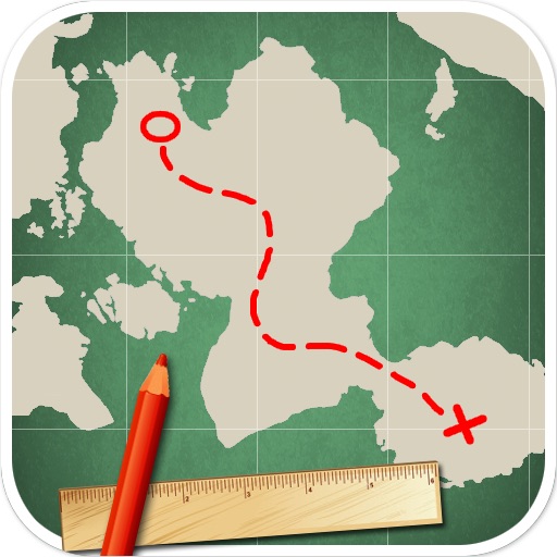
Route editor and outdoor utility
Plan your route before you start, and get track stats on the way.
Draw a route tapping on the integrated map, or import it setting start and destination addresses, or from a file and you will get immediately:
- route length
- time estimate (speed can be specified also manually)
- elevation profile
- ascent and descent
Then, once you are started, RoutePad calculates where you are along the track, and you can see:
- your current position as address, coordinates, altitude
- your current position along the elevation profile
- time estimate based on average, instant or manually specified speed
- distance, ascent, descent done and remaining
It's ideal for walking, hiking, jogging, riding, driving, flying.., it does not need to be running all the time like a tracking app, so it won't drain your device's battery.
COMPLETE FEATURES LIST
- Route editor: it’s very quick and easy to create routes directly on the Google maps with your fingers
- Length calculator
- Time estimation, based on your average, instant or a manually specified speed.
- Shows informations about your current position: address, coordinates, elevation
- Elevation profile graph
- Ascent and descent calculations
- Stopwatch
- Start time, end time and pause are editable
- Routes can be saved and reused
- Routes can be reversed
- Kilometers, miles and knots support
- Import routes from GPX or KML files
- Import automatic routes, specifying start and destination addresses
iPhone Screenshots
(click to enlarge)


App Changes
- June 24, 2011 New version 1.1.4
- November 23, 2011 New version 1.2
- November 25, 2011 Price decrease: $1.99 -> $0.99
- November 28, 2011 Price increase: $0.99 -> $1.99
- April 27, 2012 New version 1.3
- May 16, 2012 New version 1.3.1
- June 07, 2012 New version 1.3.2
- January 24, 2015 Price decrease: $1.99 -> FREE!
Other Apps From Matteo Caldari