148 Apps on Facebook 148 Apps on Twitter

Tag: Directions »

Find Your Way With This Direction for the Apple Watch

Posted by Jessica Fisher on May 8th, 2015
+ Universal & Apple Watch App - Designed for iPhone, iPad and Apple Watch

The Apple Watch's screen is small and not well suited for reading maps, so This Direction, by Emoak, breaks down your route into arrows.

Red Arrow Review

iPhone App - Designed for iPhone, compatible with iPad
By Jennifer Allen on January 6th, 2015
Our rating: starstarstarstarblankstar :: SIMPLE YET CONVENIENT
Red Arrow sticks to its name, providing you with an arrow as a heads up to your destination. It's simple, yet useful.
Read The Full Review »

ETA for iOS 8 Introduces Today View Extension and is Having a 50% Off Sale

Posted by Jessica Fisher on September 17th, 2014
iPhone & Apple Watch App - Designed for iPhone and Apple Watch, compatible with iPad
Our rating: starstarstarstarhalfstar :: GET THERE ON TIME :: Read Review »

To accompany the release of iOS 8, Eastwood has released a new update for ETA. The personal driving assistant now has a Today View extension that shows your top three locations.

ETA integrates with your favorite map apps so that you can click on a location on a map and get the ETA and directions without ever opening the app, and they have included the ability to drag and drop locations via a pin.

In celebration, ETA will be on sale throughout the iOS 8 launch week, which runs from the 17th to the 24th. You can pick up ETA for $0.99 right now on the App Store.

ETA Review

iPhone & Apple Watch App - Designed for iPhone and Apple Watch, compatible with iPad
By Charlie Miller on March 6th, 2014
Our rating: starstarstarstarhalfstar :: GET THERE ON TIME
You know where you’re going, you just need to know how long it will take. ETA wants to get you there on time.
Read The Full Review »

Garmin Navigon Apps Getting Street View Upgrade

Posted by Brad Hilderbrand on February 28th, 2012
+ Universal & Apple Watch App - Designed for iPhone, iPad and Apple Watch
Our rating: starstarstarstarhalfstar :: YOU HAVE REACHED YOUR DESTINATION :: Read Review »

At this week's Mobile World Congress in Barcelona, Garmin has announced that it will be adding Google Street View to all Navigon apps later this Spring. This new addition will allow users to get a close-up view of their destinations before they depart, letting them zoom in on target buildings or cross streets so they can more easily spot a previously unvisited locale.A specific launch date for the update was not given, but it should be arriving soon.

This upgrade is a godsend to people like me who really want a street-level view of unvisited locations. It's just so much easier, in my opinion, to find the place you're looking for when you've seen the building, know what side of the street it is on and can see what other buildings and landmarks are nearby. This addition makes an already impressive GPS app even better, and it's getting really hard for just about everyone else out there to compete with Garmin's Navigon offerings.

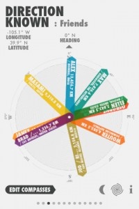
Direction Known: A Different Kind of GPS App

Posted by Rob Rich on September 6th, 2011
+ Universal App - Designed for iPhone and iPad

Know those corny signs that are up in just about any tourist-heavy area which show people which direction and how far another tourist-heavy attraction/city/state is? Something like an arrow sticking out of the ground in Maine, pointing West and proudly displaying "Hollywood: 'X' miles." Well Direction Known does something similar, only with customizable lists of things to point at and a readout that updates and syncs in real-time as the user moves around.

As someone living in a major metropolitan center, I can't exactly walk a straight line to wherever it is I need to go. However, anyone who's ever tried navigating anywhere on foot ever knows that even having a general idea of where their destination is can be a huge help. Of course, there's also the option to use the device's built-in GPS to check the map.

Direction Known does have plenty of practical uses, including finding a friend at the park, trying to figure out which direction to start walking in after getting off the subway or finding one's way out of the wilderness (if there's a signal). It also has some non-practical uses, like showing the kids how much farther until they reach grandma and grandpa's house or letting said grandparents watch their family getting closer. It can also be used for purely nostalgic purposes, such as having an arrow that always points to one's childhood home. Locations can be saved in separate groups, keeping things from getting too cluttered and giving users more control over what they're trying to find.

Upon first glance, Direction Known might look like nothing more than a colorful compass, but it can be much more than that. It can be incredibly helpful in the right situation, and it can illicit a nostalgic smile in others. Ultimately it's up to the individual user to decide. Regardless of how it's used, it's available in the App Store right now.


ParkBud Review

iPhone App - Designed for iPhone, compatible with iPad
By Gianna LaPin on May 27th, 2011
Our rating: starstarstarstarhalfstar :: LIVES UP TO THE HYPE
ParkBud is proof that functional can also be beautiful. This well-designed parking app has been soaring to the #1 position on chart after chart, and quite frankly, it does not disappoint.
Read The Full Review »

mTrip Offers A Fresh Take On The Traditional Travel App

Posted by Ben Harvell on June 23rd, 2010
+ Universal App - Designed for iPhone and iPad

While there are hundreds of travel and city guide apps for iPhone, it looks like mTrip will blow them away with its unique spin on the traditional tour guide app.

While mTrip offers users the default sightseeing tips and direction tools for a location, it goes one step further helping users plan their trip itinerary. Better than that, the app can even create an itinerary for you based on your preferences, trip duration and accommodations. Daily schedules can be edited at the user’s discretion and the app is even intelligent enough to list attractions based on their opening hours and proximity to the user.

Once you arrive at your destination you can make use of augmented reality to see where sites are in relation to your current location as well as point out restaurants, bars, hotels and other points of interest. Travelers can also swap tips on locations via the app by adding notes and viewing those of others.

All of these features make mTrip a very useful and fully featured tool but its ability to function offline is the real jewel in its crown. Your itinerary can be customized and reworked without an internet connection and augmented reality also functions in the absence of a network. Pretty much the only feature that requires the internet is the fun little postcard tool that allows users to send messages to friends from their vacation via email or Facebook.

mTrip travel guides are currently available for London, Paris, Amsterdan, Berlin, Rome, Barcelona, New York, San Francisco and Chicago in a choice of five languages. Many more locations are also planned with more information available here.

If you’re heading to one of the above locations, tack another $5.99 on to the cost of your trip for the ultimate travel experience and do it quickly before the app returns to its regular price of $9.99

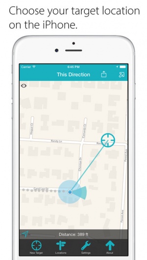
Steps Makes Directions Easy on the iPhone

Posted by Zach Sims on June 21st, 2010

I met Tarikh of Uncommon Projects a couple of weeks ago and got a preview of Steps, a cool new project designed to help users publish instructions or directions from their iPhone to the web. Uncommon Projects, based in Brooklyn, is a hardware and software design firm that has done projects like a cool series of photo bikes for Yahoo. One of the sample Steps they've put together online is a great introduction to the service's potential.

[caption id="attachment_39682" align="aligncenter" width="200" caption="List of Created Stpes"]

[/caption]

Creating Steps
At the moment, creating Steps requires the Steps iPhone application. Users start projects and add steps, with a wide variety of different types of information to include. Images and text are the two most important, but Steps also gives users the opportunity to add directional arrows that translucently sit on top of the photos. Location can also be added via GPS and seen on an included map. This allows for breadcrumb navigation using just a map in case pictures or text aren't necessary.

[caption id="attachment_39683" align="aligncenter" width="200" caption="Editing Steps"]

[/caption]

The application also allows you to preview the steps before uploading them to the web. Once shared, the app can send the steps out in a tweet or an email.

Steps Online
The Steps app makes it incredibly simple to create instructions and the web app that Uncommon Projects has created is a perfect companion. The iPhone view feels just like the application itself, allowing users to look at maps or see the text and pictures along with every step. Viewing the Steps site from a desktop provides an equally informative view.

[caption id="attachment_39686" align="aligncenter" width="300" caption="Viewing Steps\' Directions Online"]

[/caption]

A Lesson in Simplicity
Steps is just the kind of application I love. It's easy to use, simple, and beautifully designed. When the app is released, it'll make it easier for everyone, be they chefs sharing recipes or relatives giving directions to their homes, to make easy to understand walkthroughs.