
What's New
Enhanced GPS Algorithms.
App Description
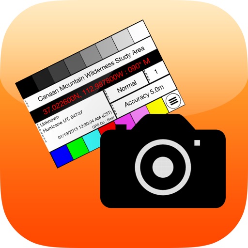
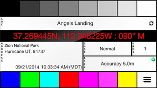
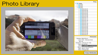
PhotoSlate is the location aware workflow assistant for digital photographers. PhotoSlate displays enhanced metadata, providing information that is not recorded by the digital camera. PhotoSlate identifies GPS coordinates, compass heading, location name and address. The photographer can enter the type of shot and the number of frames that will make up a photographic sequence. Photographing the PhotoSlate display marks the details of the upcoming photographic sequence.
PhotoSlate is ideal for photographers whose DSLRs do not have a built in GPS, or who perform complex photographic sequences like HDR, photo-stacking, panoramic, multi-frame photo stitching, and multiple exposures.
In the field, the photographer composes the shot, starts up PhotoSlate, waits for the GPS and Reverse Geocoding to complete, taps the Shot field to find the sequence type, and then taps the frames to indicate the number of shots in the sequence. The photographer then holds PhotoSlate in-front of the camera and photographs it.
Back in the digital darkroom, the photographer imports and sequences the photos in the order they were taken. The PhotoSlate photographs provide a cue-card for each photo/photo-sequence. This facilitates Geotagging, and grouping photos that belong together.
Since both the GPS and compass heading are recorded, the photographer can use tools like the Photographer’s Ephemeris, to plan a return trip when the lighting conditions are ideal.
PhotoSlate also allows the photographer to override the location name and address by simply tapping on the field to be changed. The location name and address will turn blue and a pencil icon will appear indicating that the reverse geocoding information has been overridden.
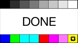
For complex sequences, or several repeats of the same scene (like shooting bracketed exposures the same subject, as the light changes) there is a “DONE” slate that can be photographed indicating that the sequences at this location are finished. For example, The photographer may set up a camera for a three shot exposure bracket, and then perform the bracket every 15 minutes until the sun sets. Back in the digital darkroom, the photographer groups each three images together until Reaching the DONE image.
PhotoSlate has many power-saving features to prevent GPS draining on the battery. When PhotoSlate is not displayed, the GPS is suspended. The GPS automatically shuts off after two minutes.Simply click the menu-icon in the lower right hand corner and then the GPS icon to start/stop the GPS.
Once PhotoSlate has found the location name and address it will not perform another reverse geocoding unless the iPhone has moved. Clicking the recycle icon to the right of the location name will refresh the displayed location name and address.
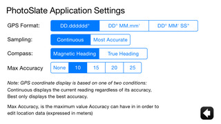
PhotoSlate has two ways of displaying the GPS coordinates: Continuous which means the most recent GPS reading is used regardless of its accuracy; Best uses only the best reading at the current location.
iPhone Screenshots
(click to enlarge)

App Changes
- March 03, 2015 Initial release
- April 27, 2015 New version 1.1
- May 25, 2015 Price decrease: $4.99 -> $0.99
- June 15, 2019 New version 1.2
Other Apps From Richard Cox