
What's New
This app has been updated by Apple to display the Apple Watch app icon.
Updated for latest iOS
App Description
● KEY FEATURES ●
● Simple, fast and easy to use.
● Designed for the first time visitor and experienced commuter.
● Unique "Travel Explorer" feature provides a view of travel times and distances from any location on the map.
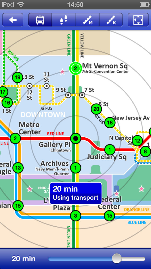
● Professionally drawn colourful and clear map with geographical features and places of interest.
● Planned route animates on the map.
● Saves and recalls favourite and recent journeys.
● Take me home feature.
● Online street map integration (when an internet connection is available).
● Services can be turned on or off, routing around problems.
● Works in both landscape and portrait modes.
● Easily locates your nearest transport stop.
● Places of interest, parks etc are built in to the application.
● OVERVIEW ● The Washington Metro - Map and route planner by Zuti makes it easy to travel in and around Washington using the WMATA Metro and the DC circulator bus routes. The application contains a professionally drawn map and route planner with many unique features. The inbuilt map provides a simple and colourful view of the city transport services with the ability to flip to an online street map view when an internet connection is available. This way the user can view the online map feature when above ground and the transport map and route planning is still fully functional underground or anywhere there is no internet connectivity. This provides the best of both worlds, the transport map and route planning anytime, anywhere and online street maps and search when a connection is available.
● TRAVEL EXPLORER ● The unique travel explorer feature provides a view of travel times using transport and on foot and distances from any location on the map. This is helpful for getting a sense of scale and connectivity of the transport system and can provide some interesting results. For example is it quicker to use the metro to go from Federal Triangle to Archives or is it quicker on foot? (Hint, the quickest route will keep you fitter). No other application makes it so easy to get around on the metro and allow you to make travel decisions based on the actual distances and estimated travel times on foot.
● ROUTING ● Does not require an internet connection and will always be available to display a clear and detailed view of the city transport system, plus list and animate the optimum route for your journey. Provides the fastest route calculations of any mobile routing application (virtually instantaneous) using actual published journey times with the ability to select the quickest route or the route with the least changes.
Comprehensive details of your planned route are provided, including “direction”, “towards” and “service frequency” information (not available on any other offline journey planner) for example “Take the Metro Blue line (Eastbound) towards Largo Town Center for 4 mins (2 stops). Service runs every 12 minutes” which is essential when finding the correct platform and direction. Also given are alternatives for each leg of the journey.
● NO INTERNET CONNECTION REQUIRED ● The map and routing do not require an internet connection and you will not be charged data connection fees. This also means the application runs perfectly underground, on an aeroplane, etc. For international visitors to a city who have data roaming turned off this is an ideal solution.
● LIVE INFO ● When an internet connection is available, optional "Live Information" on the current state of the transport services and real time WMATA station departure boards can be viewed allowing you to plan your journeys in advance and avoid any potential delays. Unique to this application is the ability to turn off services that are out of action and automatically calculate an alternative route.
● MORE MAPS ● This map is one in a series of Zuti worldwide city maps, if you like this product you may also enjoy some of our other offerings, please visit www.zuti.co.uk for further information.
iPhone Screenshots
(click to enlarge)


iPad Screenshots
(click to enlarge)


App Changes
- June 17, 2014 Initial release
- June 14, 2019 New version 4.0
Other Apps From Visual IT Ltd