What's New
Additional geographic data
Detailed trail and guided paths
Updated software
Improved performance
App Description
"Best digital road and trail map of Torres del Paine National Park."
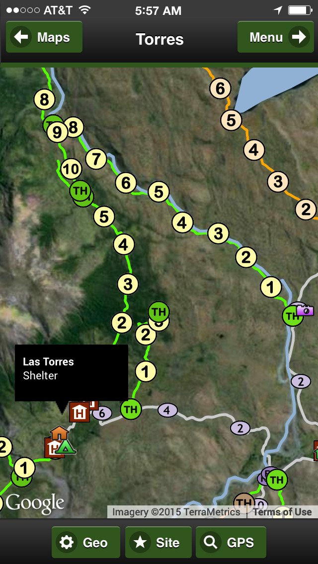
8 Base Maps:
OFFLINE Map (no internet or phone service required), 3 premium imagery map providers, 2 sets of streets, online Terrain and Topo maps
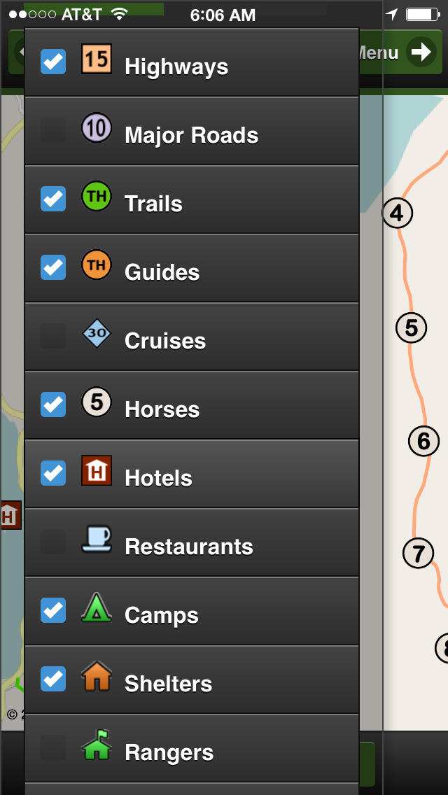
17 Geographic Overlays:
Highways, major roads, trails, guided trails, cruises, horse trails, hotels, restaurants, camps, shelters, rangers, stores, peaks, views, lakes, elevation and park boundary.
Hiking Trails in the App
Bahia Maitenes - Hiking trail = 9.4 km
Cascada Paine - Hiking trail = 8.5 km
Ferrier Peak - Hiking trail = 3.5 km
Glacier Grey - Hiking trail = 7.0 km
La Peninsula - Hiking trail = 9.9 km
Lago Brush - Hiking trail = 17 km
Lago Del Jote Norte - Hiking trail = 4.0 km
Lago Del Jote Sur - Hiking trail = 6.5 km
Lago Del Toro Norte - Hiking trail = 4.4
Lago Geikie - Hiking trail = 10.8 km
Lago Goic - Hiking trail = 6.4 km
Lago Grey East - Hiking trail = 10.0 km
Lago Grey Wharf - Hiking trail = 3.3 km
Lago Paine - Hiking trail = 11.7 km
Laguna Azul View - Hiking trail = 5.0
Laguna Verde - Hiking trail = 12.9 km
Refugio Las Torres - Hiking trail = 10 km
Refugio Los Cuernos - Hiking trail = 11.9 km
Rio De Los Hielos - Hiking trail = 3.5 km
Rio Grey - Hiking trail = 15.0 km
Rio Paine - Hiking trail = 5.7 km
Rio Paine Valley - Hiking trail = 3.3 km
Rio Paso - Hiking trail = 6.0 km
Rio Serrano - Hiking trail = 4.0 km
Rio Serrano West - Hiking trail = 12.7 km
Salto Grande Norte - Hiking trail = 3.0 km
Salto Los Perros - Hiking trail = 10.0 km
Valle Ascencio - Hiking trail = 8.3 km
Valle Del Frances - Hiking trail = 5.0 km
Valley Encantado - Hiking trail = 10.6 km
Valley Pingo - Hiking trail = 12.5 km
Guided Hikes in the App
Cabeza Del Indio - Guided Hike = 8.3 km
Camp Japones - Guided Hike = 4.6 km
Centinela Peak - Guided Hike = 10.2 km
Lago Paine Norte - Guided Hike = 11 km
Lago Quemado - Guided Hike = 9.0 km
Laguna Azul Norte - Guided Hike = 8.6 km
Laguna Cebolla - Guided Hike = 11 km
Punta Negra - Guided Hike = 4.0 km
Vega de la Paloma - Guided Hike = 8.3 km
Social Media:
Videos, Photos, Facebook and Twitter.
Services:
GPS and weather
Languages:
English, Spanish and Portuguese
iPhone Screenshots
(click to enlarge)


iPad Screenshots
(click to enlarge)


App Changes
- June 07, 2014 Initial release
- September 05, 2014 New version 5.3.0
- January 24, 2015 New version 5.5.0
- August 18, 2015 Price decrease: $4.99 -> $0.99
- June 22, 2016 Price increase: $0.99 -> $2.99
Other Apps From John Buttery