

What's New
* Bug Fixes
App Description
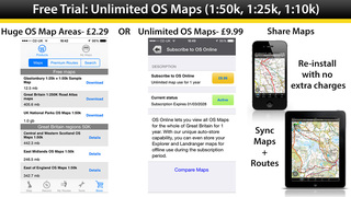
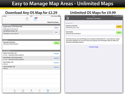
Includes a free download of all 15 GB National Parks, normally £9.99 (Ordnance Survey 1:50k).
*** Extremely easy to use and looks great. [Trek & Mountain Magazine]
*** The best way to access Ordnance Survey Maps in digital form. [Stuff Magazine]
*** The perfect tool for navigating off-road. Great Fun! [Outdoors Magazine]
OutDoors GB makes it easy to enjoy the great British countryside with confidence.
• Trusted by hikers, cyclists, ramblers, and outdoor instructors.
• At a fraction of the cost of a dedicated GPS device, spend less time staring at maps and more time stretching your legs.
• The only outdoors navigation app that combines all your favorite OS Maps, with the features you need in a simple interface.
• There is now no reason to ever get lost again.
• Simply create a route on Ordnance Survey maps..…and go!
OutDoors GB takes outdoors navigation to new heights:
• HIKERS: Find or plan a route by choosing from over 200,000 free routes. Then navigate using the built in compass & simple direction view. Track your journey by hitting the record button and finally save and share favorite spots by creating a ‘My Places” list
• RUNNERS: Add variety to your running routes by searching our database of local routes based on distance and elevation. Track your stats and save your favorite places on the routes for great views, stretching, resting and water fountains by creating your personal point of interests list
• CYCLISTS: Find a route that matches your level of intensity by searching entries by distance and elevation. Or craft your own perfect biking path with the route builder. Use the hands free mode while biking and track your route statistics
• PHOTOGRAPHERS: Find beautiful landscapes by searching through over 250,000 points of interests. Find or plan your route to get there by using distance markers and confidently explore offline with Satellite, Terrain, Hybrid, and Road maps
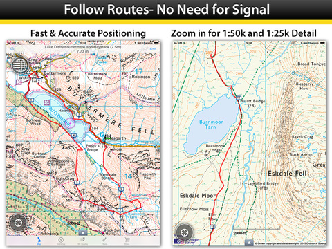
EXPLORE CONFIDENTLY
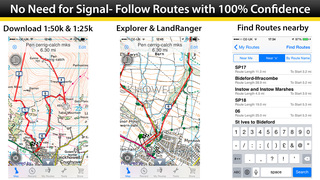
• Dependable anywhere - Break free of phone signals and download maps to use and explore anywhere
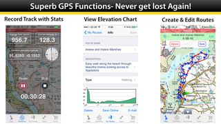
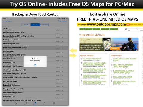
• Find, plan, share, and record routes with statistics & elevation profiles
• 200,000+ Free routes available for route planning
• Unlimited access to online & offline OS Maps (PRO)
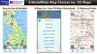
ORDNANCE SURVEY MAPS
• Download any Landranger 1:50k, Explorer 1:25k Ordnance Survey maps
• Quick access to download OS Map regions: Regions (1:50k), Counties (1:25k) or National Parks (1:25k)
POWERFUL GPS FUNCTIONS
• Fully functioning GPS at a fraction of the cost of a dedicated GPS device
• Finds your location in seconds- accurate to within 10 metres
• Create a route, with distance markers, by tapping on the screen
• Follow a planned route using the in-built compass
• Create & Share 'My Places' list (picnic area, views etc)
• 250,000 points of interest included
WEBSITE & ONLINE COMMUNITY (150,000+ MEMBERS)
• Do all your planning (or post trip analysis) with OS Maps
• Plan, edit and share your routes via Email, Text, Social, etc.
You can subscribe to OutDoors PRO for unlimited OS Maps & Premium Routes. Your subscription will be £30 for 1 year from the date of subscription, charged to your iTunes Account, and will automatically renew unless cancelled at least 24 hours before the end of the current period. Auto-renew can be turned off anytime by going to your Account Settings in iTunes after purchase. No cancellation of the current subscription is allowed during active subscription period.
Note: Continued use of GPS running in the background can dramatically decrease battery life.
Terms of Use: http://outdoorsgps.com/terms
Privacy Policy: http://outdoorsgps.com/privacy
iPhone Screenshots
(click to enlarge)

iPad Screenshots
(click to enlarge)


App Changes
- June 24, 2011 New version 2
- August 08, 2011 New version 2.1
- August 13, 2011 Price decrease: $7.99 -> $6.99
- June 16, 2012 New version 4
- January 16, 2013 Price decrease: $6.99 -> $2.99
- February 21, 2013 New version 4.1
- April 03, 2013 New version 4.2
- September 10, 2013 New version 4.3
- October 28, 2013 New version 4.4
- March 14, 2014 New version 4.5
- March 31, 2014 New version 4.5.1
- October 15, 2014 New version 4.6
- February 08, 2015 New version 4.7
- February 10, 2015 New version 4.7.1
- February 26, 2015 New version 4.7.3
- March 17, 2015 New version 4.7.5
- September 02, 2015 Price decrease: $2.99 -> $0.99
- October 19, 2015 Price increase: $0.99 -> $1.99
- November 09, 2015 New version 4.7.7
- March 15, 2016 New version 4.9
- June 22, 2016 New version 4.10.1
- November 06, 2016 New version 4.11
- January 03, 2017 New version 4.12
- June 13, 2019 New version 4.20
- June 22, 2019 New version 4.22
- June 24, 2019 New version 4.24
- August 16, 2019 New version 5.0.3
- September 11, 2019 New version 5.1
- September 23, 2019 New version 5.1.2
- September 27, 2019 New version 5.1.3
- October 14, 2019 New version 5.1.4
- November 04, 2019 New version 5.1.5
- November 11, 2019 New version 5.1.6
- July 14, 2020 New version 5.1.7
- August 05, 2021 New version 6.1
- October 03, 2023 New version 6.5.7
Other Apps From RoadTour LLC