
App Description
* In a long flight, how do we know Qibla and what time is the ground below us ?
* How do we convince ourselves with evidence of our location with reference to Ka'ba ?
WHAT IS APPLICATION ABOUT
When we are on land or at sea, we graphically place marker of our geographical location and the compelling animation will show the circles around Ka'ba reaching us. We will be guided to face the center of the circles. The circles are illustrated taking the Earth correctly as an ellipsoid (almost a sphere).
When we are on a plane, we specify our flight details and the application will guide us the Qibla with reference to the body of the plane (eg. at the tail end, towards the right wing). We can see the timing of the entire flight duration with reference to the ground-time and our iPhone time, with these information we decide when to pray.
No Internet and magnetic compasses required.
This application is just an Information Technology tool.
LANGUAGES
English, Arabic and Indonesian.
HOW TO USE (SUMMARY).
1) At the main menu.
- Press 'Land/Sea' button when we are on land, ship, train or just roaming.
- Press 'Air' button when we are in a plane.
- Press 'Find North' button to use GPS to find the direction of the Earth's True North at our current location.
- Press 'Setting' button to change the language and unit of measurement.
2) At the 'Land/Sea' View.
We specify our current location in any of the 3 methods, select the method by pressing the ball next to the method.
Big green dot - our location.
Red star-wand - standard symbol for True North, it always point to the top of our Earth and our iPhone.
Continuous green line - The concentric center at our current location with Ka'ba at center.
Small moving green dots - the path to Ka'ba. It can be a curve or a straight line.
Gold-arrow - points to Ka'ba with reference to True North.
Press 'EVIDENCE' to view the how the direction is derived.
Pinch in/out to zoom.
Green marker - our current location
Gold/Black - Ka'ba
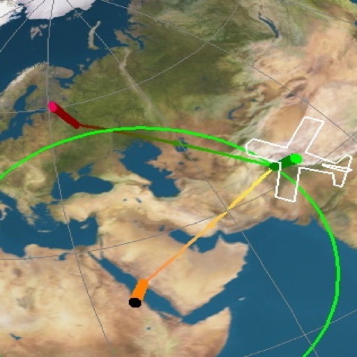
3) At the 'Air View'.
The 'Watch Time' is the clock time of the departing city.
'Ground Time' is the local clock time of the land below us.
The slider is provided so we can look forward to the timings ahead of us during the flight.
The image shows the zoom-in of the plane's body at the particular 'Watch Time',
Small moving green/red dots - the path to arrival city. It can be a curve or a straight line.
Small moving yellow/gold dots- the path to Ka'ba. It can be a curve or a straight line.
As we move the slider, the 'Watch Time' and 'Ground Time' will change correspondingly, the direction of the plane will change, Qibla will change.
Based on these information, we know when to pray and at which direction.
Press 'EVIDENCE' to view the how the direction is derived.
Green marker - Departure point
Red marker - Arrival point
Gold/Black - Ka'ba
4) At the 'Find North' View.
Usable only when we are moving on land (or sea).
If we are on foot, hold iPhone steady and walk a straight line, this allows GPS to determine our walking direction.
When screen blinks, star-wand will point to True North.
Accurate only when the screen just blink.
5) At the 'Setting' View.
Select the language and unit of measurement.
iPhone Screenshots
(click to enlarge)


App Changes
- August 12, 2012 Price decrease: $9.99 -> $7.99
Other Apps From CC Leong