
App Description
Accurate, simple to use Satellite Map based Virginia tide charts of the all NOAA based Virginia tide stations on a simple to use satellite map. Designed by Virginia fishermen and Professional Virginia Fishing Guides.
NO SPAM ADS, SIMPLE TO USE...100% AD FREE.
Other Features:
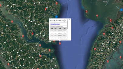
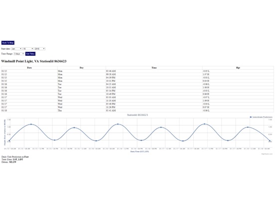
Ability to forecast Virginia tides from NOAA by setting date and period for any of the tidal stations for the entire State of Virginia tide tables.
Excellent support for any issues, questions or new features...simply email: [email protected] and we'll show you how Apple support is meant to be.
Auto-save last location for easy reference to your last tide station the next time you use the tide app.
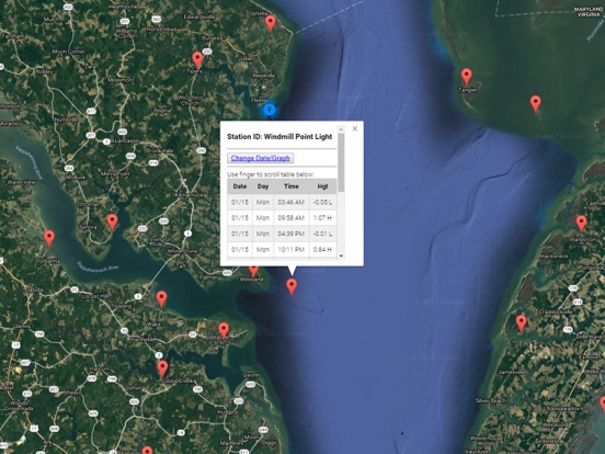
Included is the ability to zoom and view satellite imagery for fishing ground characteristics to compare with tide movement.
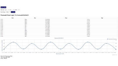
Advanced tide graphs allow for you to judge the level of water movement for optimal fishing between high and low tide in Virginia between tide stations so you can follow the tide flow for the entire day.
Recent Feedback:
"NesTides ability to display tide predictions and actual tidal flow graphs allow me to extend fishing trips by following different tide station tide charts and moving with the tide flow. The satellite view allows me to explore and discover new fishing grounds I never knew existed. Absolutely the best fishing software tool I have ever used. ," said USCG Captain Mike K.
Virginia Tide Chart stations include (partial list see website for full list):
Wallops Island,Gargathy Neck,Metompkin Inlet,Folly Creek, Metompkin Inlet,Wachapreague, Wachapreague Channel,Revel Creek, Revel Island,Great Machipongo Inlet (inside),Upshur Neck, south end,Sand Shoal Inlet (Coast Guard Station),Oyster Harbor,Smith Island (Coast Guard Station),Cape Henry,Virginia Beach,Rudee Inlet entrance,Rudee Inlet, interior channel,Rudee Heights, Lake Wesley,Lake Rudee, south end,Sandbridge,Fishermans Island,Kiptopeke Beach,Old Plantation Light,Cape Charles Harbor,Gaskins Point, Chesconessex Creek, Schooner Bay,Watts Island,Tangier Island,Muddy Creek Entrance,Guard Shore,Saxis, Starling Creek,Cornfield Harbor, Md.,Lewisetta, Va.,Travis Point, Coan River, Va.,Kinsale, Yeocomico River, Va.,Piney Point, Md.,Ragged Point, Coles Neck, Va.,Mount Holly, Nomini Creek, Va.,Colton Point, Md.,Mills Point (south of), Wicomico Riv., Md.,Colonial Beach, Va.,Dahlgren, Upper Machodoc Creek, Va.,Lower Cedar Point, Md.,Mathias Point, Va.,Goose Creek, Port Tobacco River, Md.,Riverside, Md.,Aquia Creek, Va.,Clifton Beach, Smith Point, Md.,Liverpool Point, Md.,Quantico, Va.,Indian Head, Md.,Marshall Hall, Md.,Alexandria, Va.,Bellevue, D.C.,WASHINGTON, Washington Channel, D.C.,Washington Naval Yard,Kingman Lake,Kenilworth Aquatic Garden,Bladensburg, Md.,Sunnybank, Little Wicomico River,Great Wicomico River Light,Fleeton Point,Glebe Point, Great Wicomico River,Windmill Point Light,Tappahannock,Saunders Wharf,Port Royal,Park Turn,Hopyard Landing,Massaponax,Jackson Creek, Deltaville,Dixie,Wolf Trap Light,Mobjack, East River,Belleville,Browns Bay,Tue Marshes Light,Yorktown, Goodwin Neck,Yorktown,Gloucester Point,Cheatham Annex,Roane Point,West Point,,Old Point Comfort,HAMPTON ROADS (Sewells Point),Pig Point,Town Point,Hollidays Point (Kings Highway bridge),Craney Island Light,Lafayette River,Western Branch,Norfolk,Portsmouth, Naval Shipyard,Money Point,Deep Creek Entrance,Newport News,Huntington Park,Menchville,Smithfield, Pagan River,Fort Eustis (MARAD),Burwell Bay,Kingsmill,Scotland,Jamestown,Ferry Point (bridge),Wright Island Landing,Lanexa, Chicahomny River,Claremont,Tettington, James River,Sturgeon Point,Willcox Wharf, Charles City,Jordan Point,City Point, Hopewell,Puddledock, Appomattox River,Haxall,Chester,Meadowville,Richmond Deepwater Terminal, James River,Richmond (river locks),Little Creek, NAB,CHESAPEAKE BAY BRIDGE TUNNEL,CBBT, CHESAPEAKE CHANNEL,Lynnhaven Inlet, Virginia Pilots Dock,Bayville,Buchanan Creek entrance,Brown Cove,Broad Bay Canal,Long Creek
iPhone Screenshots
(click to enlarge)
iPad Screenshots
(click to enlarge)
App Changes
- January 17, 2018 Initial release
- June 14, 2019 Price increase: $0.99 -> $9.99
- June 14, 2019 Price increase: $0.99 -> $9.99
- June 15, 2019 Price increase: $0.99 -> $9.99
- June 15, 2019 Price increase: $0.99 -> $9.99
- June 15, 2019 Price increase: $0.99 -> $9.99
- June 16, 2019 Price increase: $0.99 -> $9.99
Other Apps From Progress Technologies Inc