
App Description
Accurate, simple to use Satellite Map based New Jersey tide charts of the all NOAA based New Jersey tide stations on a simple to use satellite map. Designed by New Jersey fishermen and Professional New Jersey Fishing Guides.
NO SPAM ADS, SIMPLE TO USE...100% AD FREE.
Other Features:
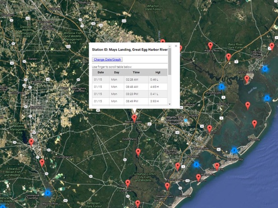
Ability to forecast New Jersey tides from NOAA by setting date and period for any of the tidal stations for the entire State of New Jersey tide tables.
Excellent support for any issues, questions or new features...simply email: [email protected] and we'll show you how Apple support is meant to be.
Auto-save last location for easy reference to your last tide station the next time you use the tide app.
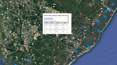
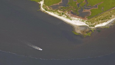
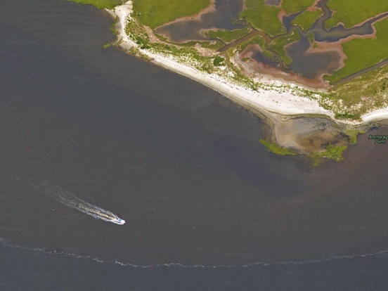
Included is the ability to zoom and view satellite imagery for fishing ground characteristics to compare with tide movement.
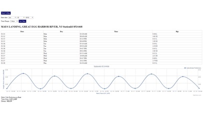
Advanced tide graphs allow for you to judge the level of water movement for optimal fishing between high and low tide in New Jersey between tide stations so you can follow the tide flow for the entire day.
Recent Feedback:
"NesTides ability to display tide predictions and actual tidal flow graphs allow me to extend fishing trips by following different tide station tide charts and moving with the tide flow. The satellite view allows me to explore and discover new fishing grounds I never knew existed. Absolutely the best fishing software tool I have ever used. ," said USCG Captain Mike K.
New Jersey Tide Chart stations include (partial list see website for full list):
Atlantic Highlands,SANDY HOOK (Fort Hancock),Highlands, Route 36 bridge,Oceanic Bridge, Navesink River,Red Bank, Navesink River,Sea Bright,Gooseneck Point, bridge,Long Branch Reach,Shark River Island, fixed RR. bridge,Shark River Hills,New Bedford,Long Branch (fishing pier),Belmar, Atlantic Ocean,Manasquan Inlet, USCG Station,Brielle, Route 35 bridge,Riviera Beach,Beaverdam Creek entrance,Beaverdam Creek, inside,Forge Pond,Tall Pines Camp,Seaside Heights, ocean,Mantoloking,Kettle Creek, Green Island,Ocean Beach,Silver Bay, Silver Bay Marina,Goose Creek entrance,Coates Point,Toms River (town), Toms River,Seaside Park,Barnegat Pier,Sloop Creek,Cedar Creek,Island Beach,Stouts Creek,Forked River,Oyster Creek,Island Beach, Sedge Islands,Waretown,Barnegat Inlet, USCG Station,High Bar,Double Creek,Loveladies Harbor,Flat Creek,North Beach,Manahawkin Creek,Manahawkin Drawbridge,Mill Creek, 1 n.mi. above entrance,Cedar Run,upper end,Beach Haven Crest,Westecunk Creek entrance,West Creek, Westecunk Creek,Parker Run, upper end,Tuckerton Creek entrance,Tuckerton, Tuckerton Creek,Beach Haven Coast Guard Station,Shooting Thorofare, Little Egg Inlet,Little Sheepshead Creek,Seven Island, Newmans Thorofare,Graveling Point,Nacote Creek,Tuckahoe River,Cedar Swamp Creek, Tuckahoe River,River Bend Marina, Great Egg Harbor River,Mays Landing, Great Egg Harbor River,Strathmere, Strathmere Bay,Middle Thorofare, Ocean Drive bridge,Ludlam Bay, west side,Ocean Drive bridge,Townsend Sound,Stites Sound,Ingram Thorofare,Long Reach, Ingram Thorofare,Stone Harbor, Great Channel,Nummy Island, Grassy Sound Channel,West Wildwood, Grassy Sound,Old Turtle Thorofare, RR. bridge,Wildwood Crest, ocean pier,Swain Channel, Taylor Sound,Wildwood Crest, Sunset Lake,Cape May Harbor,Cape Island Creek, Cape May,Cape May, Atlantic Ocean,Brandywine Shoal Light,Cape May Point, Sunset Beach,Cape May, ferry terminal,North Highlands Beach,Dias Creek, Route 47 bridge,Bidwell Creek entrance,Bidwell Creek,Dennis Creek,Dennis Creek, Route 47 bridge,West Creek,Maurice River Cove,Bivalve,Mauricetown,Port Elizabeth, Manumuskin River,Menantico Creek entrance,Millville,Dividing Creek entrance,Weir Creek bridge, Dividing Creek,Fishing Creek entrance,Fortescue Creek,Hollywood Beach, The Glades,Money Island, Nantuxent Creek entrance,Newport Landing, Nantuxent Creek,Cedar Creek entrance, Nantuxent Cove,Back Creek entrance, Nantuxent Cove,Ship John Shoal,Greenwich Pier, Cohansey River,Tindalls Wharf, Cohansey River
iPhone Screenshots
(click to enlarge)
iPad Screenshots
(click to enlarge)


App Changes
- January 17, 2018 Initial release
- June 13, 2019 Price increase: $0.99 -> $9.99
- June 13, 2019 Price increase: $0.99 -> $9.99
- June 14, 2019 Price increase: $0.99 -> $9.99
- June 14, 2019 Price increase: $0.99 -> $9.99
- June 15, 2019 Price increase: $0.99 -> $9.99
- June 15, 2019 Price increase: $0.99 -> $9.99
- June 16, 2019 Price increase: $0.99 -> $9.99
Other Apps From Progress Technologies Inc