
App Description
Accurate, simple to use Satellite Map based South Carolina tide charts of the all NOAA based South Carolina tide stations on a simple to use satellite map. Designed by South Carolina fishermen and Professional South Carolina Fishing Guides.
NO SPAM ADS, SIMPLE TO USE...100% AD FREE.
Other Features:
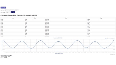
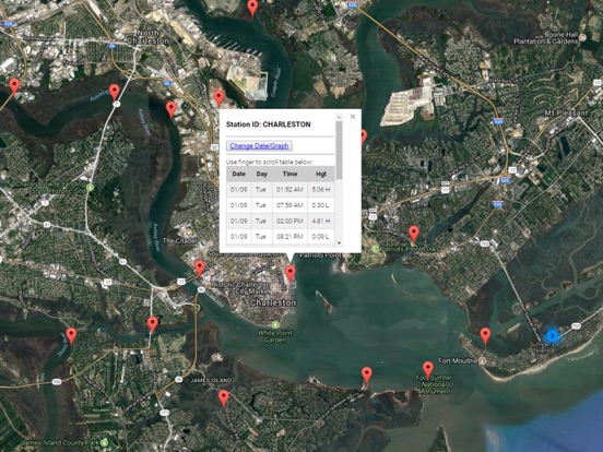
Ability to forecast South Carolina tides from NOAA by setting date and period for any of the tidal stations for the entire State of South Carolina tide tables.
Excellent support for any issues, questions or new features...simply email: [email protected] and we'll show you how Apple support is meant to be.
Auto-save last location for easy reference to your last tide station the next time you use the tide app.
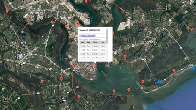
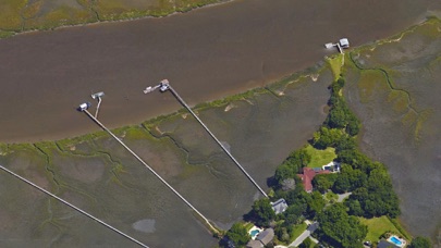
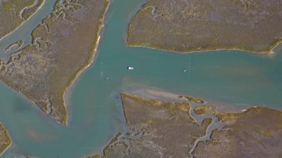
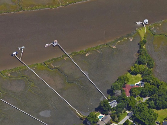
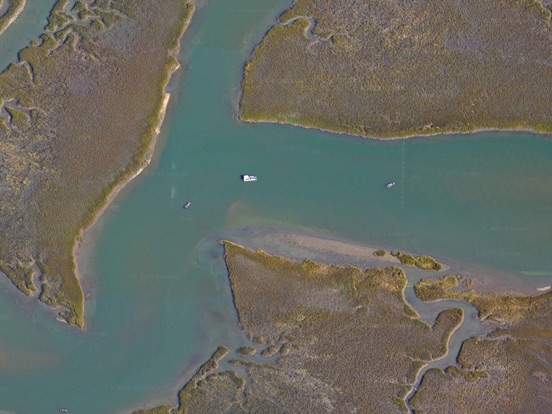
Included is the ability to zoom and view satellite imagery for fishing ground characteristics to compare with tide movement.
Advanced tide graphs allow for you to judge the level of water movement for optimal fishing between high and low tide in South Carolina between tide stations so you can follow the tide flow for the entire day.
Recent Feedback:
"NesTides ability to display tide predictions and actual tidal flow graphs allow me to extend fishing trips by following different tide station tide charts and moving with the tide flow. The satellite view allows me to explore and discover new fishing grounds I never knew existed. Absolutely the best fishing software tool I have ever used. ," said USCG Captain Mike K.
South Carolina Tide Chart stations include (partial list see website for full list):
Dunn Sound, Little River Inlet,Dunn Sound, north end,Dunn Sound, west end,Little River Neck, north end,Cherry Grove (inside),Hog Inlet Pier,MYRTLE BEACH, SPRINGMAID PIER,Garden City Pier (ocean),Murrells Inlet,Garden City Bridge, Main Creek,Divine's Dock,Smith's Dock,Captain Alex's Marina, Parsonage Creek,Oaks Creek, 0.5 mi. above entrance,Allston Creek,Oaks Creek, upper end,Litchfield Beach bridge,Midway Inlet North, Pawleys Island,Bennet's Dock, Pawleys Island Creek,Pawleys Island Pier (ocean),Ward's Dock, Pawleys Inlet,Clambank Creek, Goat Island, North Inlet,Intracoastal Waterway,Little River (town),Nixon Crossroads,Myrtle Beach Airport,North Myrtle Beach, ICWW,Myrtle Beach, Combination Bridge,Socastee Bridge,Winyah Bay,Winyah Bay Entrance (South Jetty),Georgetown Lighthouse,South Island Plantation (C.G. Station),South Island Ferry, Intracoastal Waterway,Frazier Point,Sampit River,Georgetown,Jacobs Wharf,Cumberland,Great Pee Dee River,Windsor Plantation, Black River,Black River (south of Dunbar),Winea Plantation, Black River,Mt. Pleasant Plantation, Black River,Rhems, Black Mingo Creek, Black River,Weymouth Plantation,Carr Creek, 1 mile above entrance,South of Sam Worth Game Management Area,Arundel Plantation,Holly Grove Plantation,Lower Topsaw Landing,Yauhannah Bridge,Waccamaw River,Waccamaw River Entrance,Hagley Landing,Thoroughfare Creek entrance,Wachesaw Landing,Bull Creek entrance,Little Bull Creek entrance, Bull Creek,Bucksport,Enterprise Landing,Keysfield,Pitch Landing,Conway, RR. bridge,Grahamville,North Santee River Inlet,Cedar Island, North Santee Bay,Minim Creek ent., ICWW, North Santee Bay,North Santee Bridge,Cedar Island Point,Calibogue Cay, Broad Creek, Hilton Head Island,Broad Creek, Hilton Head Island,Haig Point, Daufuskie Island, Cooper River,Bull Creek, Bull Island South, Cooper River,Pine Island, Ramshorn Creek, Cooper River,Savage I., Savage Creek, Bull Creek,New River,Bloody Point, Daufuskie Island,Hargray Pier, Daufuskie Island,Daufuskie Landing, Daufuskie Island,Doughboy Island,Good Hope Landing, south of,Cook Landing Cemetery,Rt. 170 bridge,May River,Moreland Cemetery,Bull Island North,Bluffton,Fields Cut, Wright River,Turnbridge Landing, Salt Water Creek
iPhone Screenshots
(click to enlarge)
iPad Screenshots
(click to enlarge)

App Changes
- January 10, 2018 Initial release
- January 11, 2018 Price increase: $0.99 -> $4.99
- January 11, 2018 Price decrease: $4.99 -> $0.99
- January 11, 2018 Price increase: $0.99 -> $4.99
- January 11, 2018 Price decrease: $4.99 -> $0.99
- January 11, 2018 Price increase: $0.99 -> $4.99
- January 11, 2018 Price decrease: $4.99 -> $0.99
- January 11, 2018 Price increase: $0.99 -> $4.99
- January 11, 2018 Price decrease: $4.99 -> $0.99
- January 11, 2018 Price increase: $0.99 -> $4.99
- January 11, 2018 Price decrease: $4.99 -> $0.99
- January 11, 2018 Price increase: $0.99 -> $4.99
- June 14, 2019 Price increase: $4.99 -> $9.99
- June 14, 2019 Price increase: $4.99 -> $9.99
- June 15, 2019 Price increase: $4.99 -> $9.99
- June 15, 2019 Price increase: $4.99 -> $9.99
- June 15, 2019 Price increase: $4.99 -> $9.99
- June 17, 2019 Price increase: $4.99 -> $9.99
Other Apps From Progress Technologies Inc