
What's New
- Performance in route/track drawing algorithm.
- Monetization for hosting costs.
App Description
Download high resolution National Park Service and USGS Topography maps of the Hawaiian Islands on your iPhone and iPad for GPS** offline use!
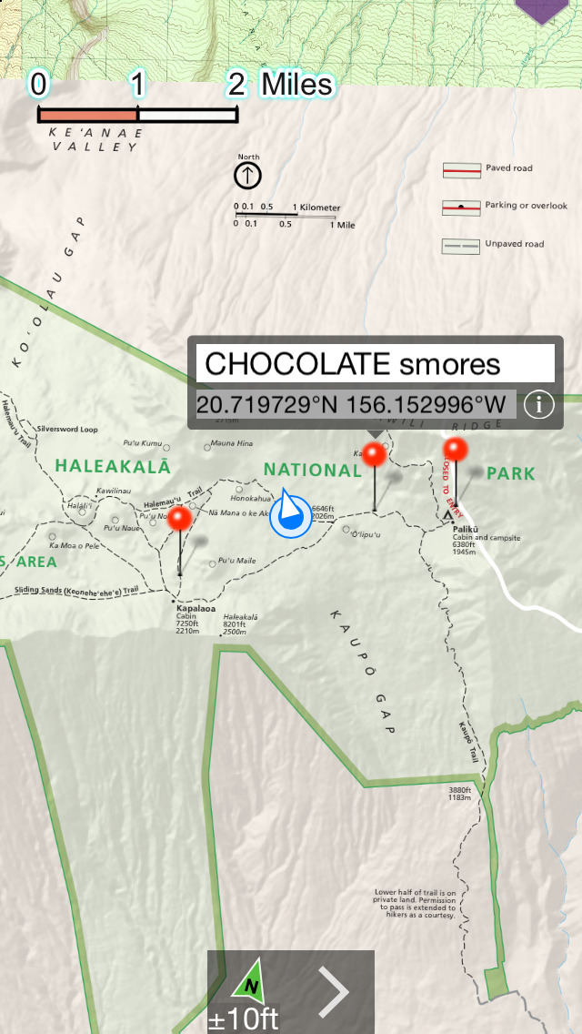
NP Maps Haleakalā app integrate official National Park Service map of Haleakalā and topography maps for you to see your location them realtime. Designed for offline use, NPMaps Heleakalā also downloads official U.S. Geological Survey topography maps displaying geographies for each Island of Hawaii!*
With a subscription purchase, you can have complete map coverage for travel from where you start your travel on Maui to Haleakalā Crater and for the all the Hawaiian Islands too. Because many national park regions and parts of the Islands may have no data service, select and download maps now or while online for your travels so you can enjoy using this app as it was intended: no internet connection. And, this app can detect internet service and automatically install USGS topography or NPS map for your current location if not already done.
Logical and intuitive to use. Park and topography maps are geospatially integrated with Apple Maps for a familiar interface and for navigating a visual catalog of maps. A marvelous index into an extensive library covering all Hawaiian Islands allows you to select maps for install all with a simple touch along your planned route of travel.
All downloaded map remain fully functional even after a subscription period ends.
Features:
• Preloaded with the NPS and USGS topography maps for Haleakalā National Park
• Access a library of 120 NPS and 67,000 USGS topography maps
• Full rendering high resolution maps
• Find geographic features worldwide with a powerful geo-code search
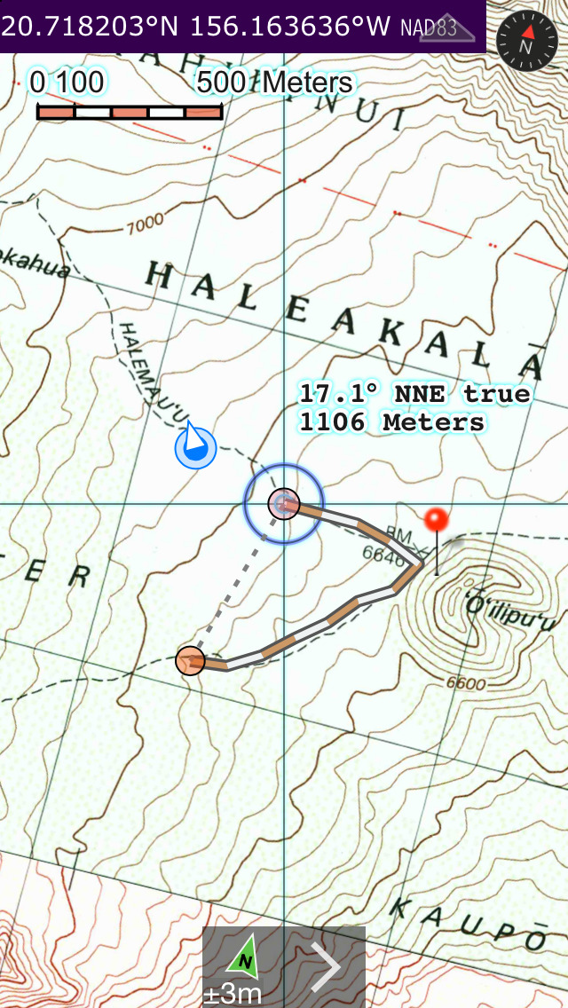
• Waypoints
• Track/bread-crumbs GPS** path recording
• Route path creation
• Shows your current GPS** location and heading reference
• Dual mode ruler with orthographic line and path measuring
• Full app usability while maps download in the background
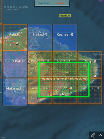
• Footprint grid index with quadrangle names for visual map selection
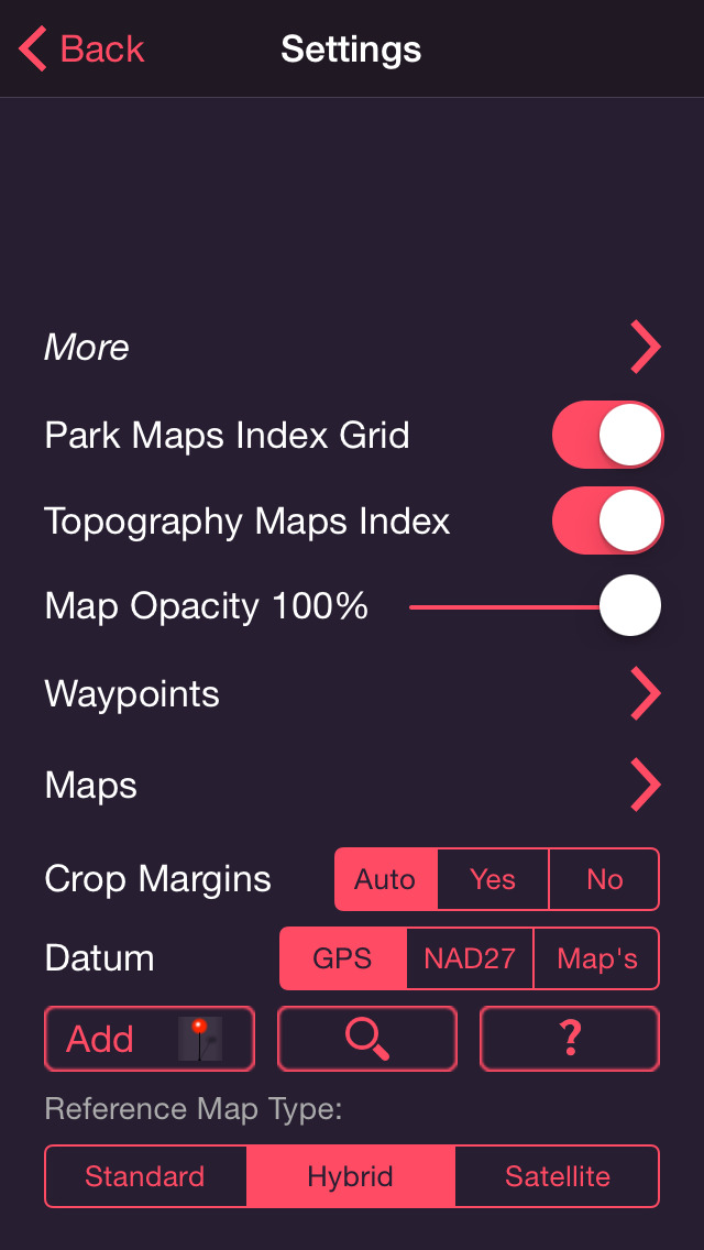
• Aligns differing map datums to the WGS84/GPS coordinates
• Automatic map download for your current location
• Miles, Feet, Kilometers, Meters, Nautical Miles units
• Latitude and Longitude coordinate display in decimal or arc minutes and seconds
• Import geospatial PDF map files via web, email attachment & iTunes
• Import and export waypoints using GPX format
• Detailed integrated help
• Supports rotation and follows heading map orientations
• No need for cellular service to use installed maps
• No subscription required to use app. Downloaded maps remain fully functional after subscription period ends. Subscription is share with other Delcartes NP Maps apps. This covers to cost of internet services.
National Parks:
Haleakalā National Park
Historical USGS topography maps scales:
24K : 1 7.5x7.5 arc minute quadrangles
25K : 1
62.5K : 1
100K : 1
250K : 1
* Not preloaded with all maps. Select and install maps you need. WiFi recommended.
** Continued use of GPS running in the background can dramatically decrease battery life. Some iPad & iPod models do not have GPS and compass hardware.
iPhone Screenshots
(click to enlarge)


iPad Screenshots
(click to enlarge)


App Changes
- July 31, 2015 Initial release
- August 04, 2015 Price decrease: $1.99 -> $0.99
- August 22, 2015 New version 3.2
- August 25, 2015 Price increase: $0.99 -> $1.99
- September 01, 2015 Price decrease: $1.99 -> $0.99
- September 06, 2015 Price decrease: $0.99 -> FREE!
- September 10, 2015 Price increase: FREE! -> $1.99
- February 27, 2016 Price decrease: $1.99 -> $0.99
- March 05, 2016 New version 4.0
- March 05, 2016 Price decrease: $0.99 -> FREE!
- December 22, 2016 New version 5.1
Other Apps From Delcartes LLC