
What's New
• Performance Improvements – Older iPad and iPhone models may notice a significant improvement in UI responsiveness.
• Track recording now records while not using the app since a new property setting is required for location services to run backgrounded in iOS9.
App Description
NP Maps Texas app integrates official National Park Service maps of Texas to find your location and on these maps realtime for GPS** and offline use. As an additional feature, NP Maps Texas can download every official historical topography map within Texas recorded by the United States Geological Survey with maps dating as far back to year 1885.*
NP Maps Texas come with 24 built in maps and allows for three free USGS topographic and NPS map downloads. Purchase an subscription period and you can have complete map coverage for travel from where you start to every National Park in the Texas republic. Plus keep and use these maps forever even after your subscription period ends with no loss of features. Because many park regions have no data service, select and download maps now or while online for your travels so you can enjoy using this app as it was intended: no internet connection. And, this app can detect internet service and automatically install USGS topography or NPS map for your current location if not already done.
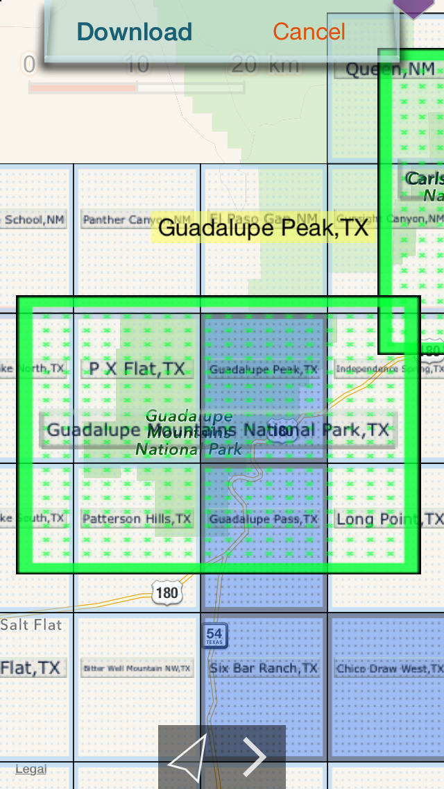
Logical and intuitive to use. Park and topography maps are geospatially integrated with Apple Maps for a familiar interface and for navigating a visual catalog of maps. A marvelous index into an extensive library covering all of Texas allows you to select maps for install all with a simple touch along your planned route of travel.
Features:
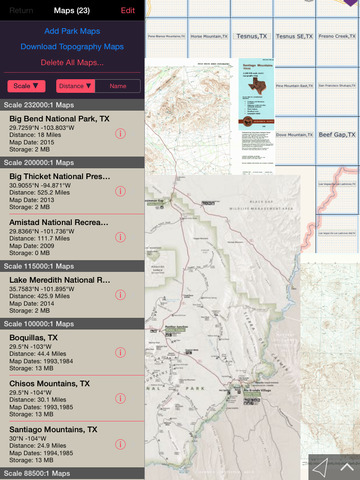
• Preloaded with 24 NPS, USGS, and US Forest Service maps
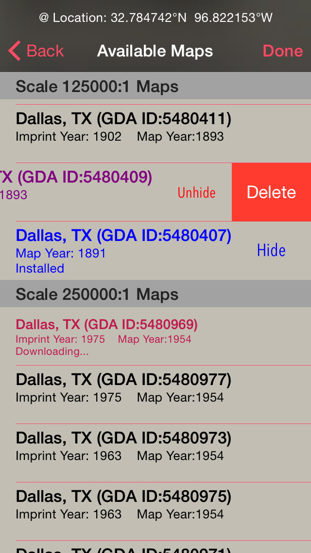
• Unlimited downloads from a library of over 12,000 maps
• Maps display at full resolution
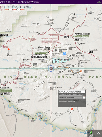
• Shows your current GPS location and elevation
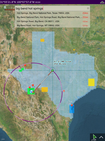
• Find geographic features worldwide with a powerful geo-code search
• Waypoints
• Route path creation
• Track/bread-crumb GPS location recording**
• Dual mode ruler with orthographic line and path measuring
• Full app usability while maps download in the background
• Footprint grid index with quadrangle names for visual map selection
• Aligns differing map datums to the WGS84/GPS coordinates
• Automatic map download for your current location
• Miles, Feet, Kilometers, Meters, Nautical Miles units
• Latitude and Longitude coordinate display in decimal or arc minutes and seconds
• Import geospatial PDF map files via web, email attachment & iTunes
• Import and export waypoints using GPX format
• Detailed integrated help
• No need for cellular service to use installed maps
• No advertisements
Below are the of National Park Service maps available for downloading,
National Parks:
Big Bend National Park (built in /w topography maps)
Carlsbad Caverns National Park (built in /w topography maps)
Guadalupe Mountains National Park (built in /w topography maps)
National Recreation Areas:
Amistad National Recreation Area (built in)
Chickasaw National Recreation Area
Lake Meredith National Recreation Area (built in)
National Preserves & Reserves:
Big Thicket National Preserve (built in)
National Historical Park:
San Antonio Missions National Historical Park (built in)
National Seashore:
Padre Island National Seashore (built in)
Historical USGS topography maps of Texas scales:
24K : 1 7.5x7.5 arc minute quadrangles
48K : 1
62.5K : 1
100K : 1
125K : 1
250K : 1
12,432 total USGS maps covering all of Texas available for download.
* Not preloaded with all USGS and NPS maps. WiFi recommended for map downloading.
** Continued use of GPS running in the background can dramatically decrease battery life.
iPhone Screenshots
(click to enlarge)


iPad Screenshots
(click to enlarge)


App Changes
- July 31, 2015 Initial release
- August 08, 2015 Price decrease: $9.99 -> $8.99
- August 11, 2015 Price decrease: $8.99 -> $6.99
- August 12, 2015 Price decrease: $6.99 -> $5.99
- August 15, 2015 Price decrease: $5.99 -> $4.99
- August 21, 2015 Price decrease: $4.99 -> $0.99
- August 25, 2015 New version 3.2
- August 25, 2015 Price increase: $0.99 -> $3.99
- August 27, 2015 Price decrease: $3.99 -> $2.99
- August 31, 2015 Price decrease: $2.99 -> $0.99
- September 05, 2015 Price decrease: $0.99 -> FREE!
- February 19, 2016 New version 4.0
- February 19, 2016 New version 4.0
- March 05, 2016 New version 4.0.1
Other Apps From Delcartes LLC